IMAGES TAKEN NEAR TO
High Street, ST. ALBANS, AL4 9DG
Introduction
This page details the photographs taken nearby to High Street, AL4 9DG by members of the Geograph project.
The Geograph project started in 2005 with the aim of publishing, organising and preserving representative images for every square kilometre of Great Britain, Ireland and the Isle of Man.

There are currently over 7.5m images from over14,400 individuals and you can help contribute to the project by visiting https://www.geograph.org.uk
Image Map
Images are licensed for reuse under creativecommons.org/licenses/by-sa/2.0
Notes
- Clicking on the map will re-center to the selected point.
- The higher the marker number, the further away the image location is from the centre of the postcode.
Image Listing (73 Images Found)
Images are licensed for reuse under creativecommons.org/licenses/by-sa/2.0
Image
Details
Distance
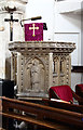
1
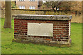
St Leonard's church, Sandridge
Looking East from TL171106 to St Leonard's church (with a steeple).
Image: © Rob Hinkley
Taken: 28 Mar 2005
0.04 miles
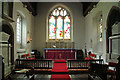
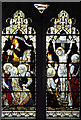
5
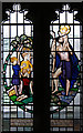
St Leonard, Sandridge - Stained glass window
Image: © John Salmon
Taken: 14 Mar 2013
0.06 miles
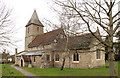
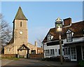
8
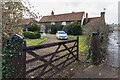
Pound Farm
Late 15th/early 16th Century farmhouse, externed and altered in subsequent centuries. Grade II listed - see www.historicengland.org.uk/listing/the-list/list-entry/1347234.
Image: © Ian Capper
Taken: 13 Nov 2020
0.06 miles
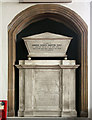
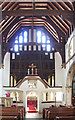
9
St Leonard, Sandridge - Stained glass window
Image: © John Salmon
Taken: 14 Mar 2013
0.06 miles