IMAGES TAKEN NEAR TO
Richmond Walk, ST. ALBANS, AL4 9BA
Introduction
This page details the photographs taken nearby to Richmond Walk, AL4 9BA by members of the Geograph project.
The Geograph project started in 2005 with the aim of publishing, organising and preserving representative images for every square kilometre of Great Britain, Ireland and the Isle of Man.

There are currently over 7.5m images from over14,400 individuals and you can help contribute to the project by visiting https://www.geograph.org.uk
Image Map
Images are licensed for reuse under creativecommons.org/licenses/by-sa/2.0
Notes
- Clicking on the map will re-center to the selected point.
- The higher the marker number, the further away the image location is from the centre of the postcode.
Image Listing (9 Images Found)
Images are licensed for reuse under creativecommons.org/licenses/by-sa/2.0
Image
Details
Distance
4
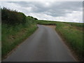
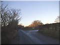
Narrow lane with passing place near to Sandridge
You can see at the passing place that the soil around here is very sandy. There are numerous old sand workings nearby.
Image: © Bikeboy
Taken: 17 Jun 2012
0.07 miles
6
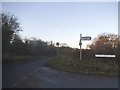
Nashes Farm Lane at the junction of House Lane
Image: © David Howard
Taken: 5 Jan 2017
0.08 miles
7
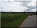
Hill top near Nashe's farm looking towards Marshalswick
Image: © Bikeboy
Taken: 17 Jun 2012
0.22 miles
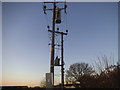
8
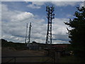
Mobile phone masts and assorted junk near Nashe's Farm
Image: © Bikeboy
Taken: 17 Jun 2012
0.24 miles
9
Electricity poles by Nashe's Farm Sandridge
Image: © David Howard
Taken: 5 Jan 2017
0.25 miles