IMAGES TAKEN NEAR TO
Codicote Road, ST. ALBANS, AL4 8DS
Introduction
This page details the photographs taken nearby to Codicote Road, AL4 8DS by members of the Geograph project.
The Geograph project started in 2005 with the aim of publishing, organising and preserving representative images for every square kilometre of Great Britain, Ireland and the Isle of Man.

There are currently over 7.5m images from over14,400 individuals and you can help contribute to the project by visiting https://www.geograph.org.uk
Image Map
Images are licensed for reuse under creativecommons.org/licenses/by-sa/2.0
Notes
- Clicking on the map will re-center to the selected point.
- The higher the marker number, the further away the image location is from the centre of the postcode.
Image Listing (90 Images Found)
Images are licensed for reuse under creativecommons.org/licenses/by-sa/2.0
Image
Details
Distance
1
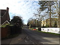
B653 Codicote Road, Wheathampstead
At the junction with Waddling Lane
Image: © Geographer
Taken: 19 Jan 2016
0.02 miles
2
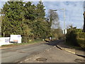
B653 Codicote Road, Wheathampstead
At the junction with Waddling Lane
Image: © Geographer
Taken: 19 Jan 2016
0.02 miles
3
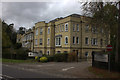
St Albans High School for girls, Wheathampstead
Image: © Robert Eva
Taken: 2 Oct 2017
0.04 miles
4
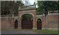
School gates, Wheathampstead
Presumably, this is the main gate to St Albans High School for girls.
Image: © Robert Eva
Taken: 2 Oct 2017
0.05 miles
5
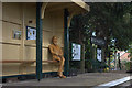
George Bernard Shaw at Wheathampstead station
Bernard Shaw travelled regularly from Wheathampstead to London. He would cycle to the station from his home in Ayot St Lawrence and leave his bike at the Railway Hotel.
Image: © Robert Eva
Taken: 2 Oct 2017
0.06 miles
6
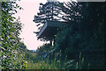
Wheathampstead railway station (disused)
Viewed from where the railway track would have been, looking west into the late afternoon sun. The chestnut paling fence beyond the platform, was all there was to prevent stray walkers from falling into the abyss, the bridge having been removed.
Image: © Jeremy Withrington
Taken: Unknown
0.06 miles
7
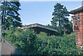
Wheathampstead railway station (disused)
Viewed through the gap between The Abbot John public house and the retaining wall of the railway bridge over the B651. The bridge had been removed by the time of the photograph. The Abbot John has since been demolished.
Image: © Jeremy Withrington
Taken: Unknown
0.06 miles
8
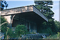
Wheathampstead railway station (disused)
Viewed from where the railway track would have been, looking east. Judging by the date painted on the awning, it was last inspected on the 9th. March 1960.
Image: © Jeremy Withrington
Taken: Unknown
0.06 miles
9
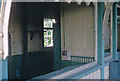
Wheathampstead railway station (disused)
One of the rooms behind the platform, viewed through where there had presumably, been a window.
Image: © Jeremy Withrington
Taken: Unknown
0.06 miles
10
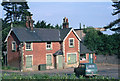
Wheathampstead railway station (disused)
The house on the corner between the B651 and Codicote Road viewed from the north side of the Lower Luton Road. The single-storey extension to the right was being used for selling coal. The station can be seen behind the house.
Since this photograph, the house and everything in the foreground has been removed to make way for a large roundabout.
Image: © Jeremy Withrington
Taken: Unknown
0.06 miles