IMAGES TAKEN NEAR TO
East Lane, ST. ALBANS, AL4 8BP
Introduction
This page details the photographs taken nearby to East Lane, AL4 8BP by members of the Geograph project.
The Geograph project started in 2005 with the aim of publishing, organising and preserving representative images for every square kilometre of Great Britain, Ireland and the Isle of Man.

There are currently over 7.5m images from over14,400 individuals and you can help contribute to the project by visiting https://www.geograph.org.uk
Image Map (Loading...)


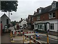
Getting Data...Please wait
Leaflet Map data © OpenStreetMap
Images are licensed for reuse under creativecommons.org/licenses/by-sa/2.0
Notes
- Clicking on the map will re-center to the selected point.
- The higher the marker number, the further away the image location is from the centre of the postcode.
Image Listing (136 Images Found)
Images are licensed for reuse under creativecommons.org/licenses/by-sa/2.0
Image
Details
Distance
1
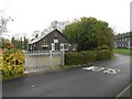
Wheathampstead: Mead Hall
Mead Hall in East Lane is the local WI Hall.
Image: © Nigel Cox
Taken: 23 Jan 2016
0.01 miles
2
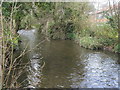
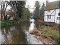
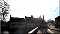
River Lea
River Lea flowing by the East Lane car park
Image: © Shaun Ferguson
Taken: 28 Mar 2010
0.03 miles
3
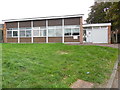
Wheathampstead Telephone Exchange
Situated in East Lane, this TE is of a standard design dating from the late 1960s. It has the code SMWTD and provides telephone and broadband services to 2,087 residential and 109 non-residential premises in Wheathampstead plus Blackmore End and Coleman Green nearby. A square white BT warning notice can be seen on this building, whilst the entrance to the TE is to the right. The numbering range of this TE is (01582) 83xxxx, the (01582) referring to the Luton group of ten TEs, and its postcode is AL4 8BH.
Image: © David Hillas
Taken: 15 Sep 2018
0.05 miles
4
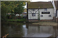
River Lea at Wheathampstead
On the opposite bank is part of the Bull Inn
Image: © Robert Eva
Taken: 2 Oct 2017
0.05 miles
5
River Lee in Wheathampstead (2)
Please compare with Image] taken from the same place by the same photographer eight and half years previously...
Image: © Nigel Cox
Taken: 23 Jan 2016
0.05 miles
6
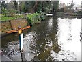
River Lee in Wheathampstead (3)
This is the view looking downstream from the High Street bridge. The River Lee sign is unusual and the photographer wonders if it is something unique to Wheathampstead or whether others exist elsewhere along the river. Anyway it points upstream to "Leagrave 13 miles" and away downstream to the "River Thames 29 miles".
Image: © Nigel Cox
Taken: 23 Jan 2016
0.06 miles
7
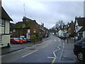
Wheathampstead Village
Looking up from the bottom of the High Street
Image: © Gary Fellows
Taken: 10 Jan 2008
0.06 miles
8
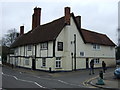
The Bull public house, Wheathampstead
On High Street.
Image: © JThomas
Taken: 18 Mar 2017
0.06 miles
10
Miller & Carter, Wheathampstead
Off the B651 High Street
http://www.millerandcarter.co.uk/restaurants/east-of-england/millerandcarterwheathampstead
Image: © Geographer
Taken: 19 Jan 2016
0.06 miles