IMAGES TAKEN NEAR TO
Smallford Lane, ST. ALBANS, AL4 0SA
Introduction
This page details the photographs taken nearby to Smallford Lane, AL4 0SA by members of the Geograph project.
The Geograph project started in 2005 with the aim of publishing, organising and preserving representative images for every square kilometre of Great Britain, Ireland and the Isle of Man.

There are currently over 7.5m images from over14,400 individuals and you can help contribute to the project by visiting https://www.geograph.org.uk
Image Map (Loading...)


Getting Data...Please wait
Leaflet Map data © OpenStreetMap
Images are licensed for reuse under creativecommons.org/licenses/by-sa/2.0
Notes
- Clicking on the map will re-center to the selected point.
- The higher the marker number, the further away the image location is from the centre of the postcode.
Image Listing (11 Images Found)
Images are licensed for reuse under creativecommons.org/licenses/by-sa/2.0
Image
Details
Distance
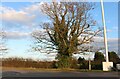
1
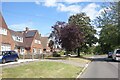
Sleapshyde Lane
The 20th century extension to the old hamlet of Sleapshyde.
Image: © Des Blenkinsopp
Taken: 25 Aug 2024
0.03 miles
3
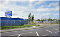
WOW Storage, Smallford Lane
Part of a small business park beside Smallford Lane.
Image: © Des Blenkinsopp
Taken: 25 Aug 2024
0.07 miles
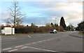
4
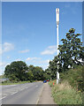
Mast by Smallford Lane
Smallford Lane is a busy semi-suburban kind of road between Hatfield and St Albans.
It may well have been a lane long ago.
Image: © Des Blenkinsopp
Taken: 25 Aug 2024
0.08 miles
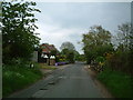
5
Smallford Lane, Sleapshyde
Outside Smallford Works
Image: © David Howard
Taken: 10 Feb 2022
0.10 miles
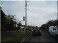
7
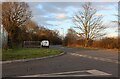
Smallford Lane, Sleapshyde
A large industrial site is on the left.
Image: © David Howard
Taken: 10 Feb 2022
0.12 miles
8
Sleapshyde
Marked as Sleepshyde on the old map. This picture shows Sleapshyde Lane.
Image: © Ray Stanton
Taken: 7 May 2006
0.14 miles

10
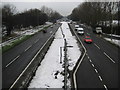
A414 North Orbital Road at Colney Heath (1)
The North Orbital Road was an early precursor to the M25 Motorway and was planned in the 1920s as a road circulating around the north side of London at about a 20 mile radius of Charing Cross. It was planned to start at Colnbrook on the A4 and, skirting past Rickmansworth, St Albans, Hatfield, Hoddesdon, and Brentwood, to terminate at Tilbury, a distance of about 75 miles. In the event only sections of it got built before the Second World War intervened. Some sections of it were then planned to be incorporated into Ringway 4, the outermost of the four London ringways that were designed, but never built, in the 1970s.
This is taken, with snow still on the ground, from the footbridge looking towards the north-eastern end of the approximate 400 metre long dog-bone roundabout at Colney Heath. Please see Image for the view in the opposite direction.
Image: © Nigel Cox
Taken: 14 Jan 2010
0.23 miles