IMAGES TAKEN NEAR TO
Jove Gardens, ST. ALBANS, AL4 0LP
Introduction
This page details the photographs taken nearby to Jove Gardens, AL4 0LP by members of the Geograph project.
The Geograph project started in 2005 with the aim of publishing, organising and preserving representative images for every square kilometre of Great Britain, Ireland and the Isle of Man.

There are currently over 7.5m images from over14,400 individuals and you can help contribute to the project by visiting https://www.geograph.org.uk
Image Map
Images are licensed for reuse under creativecommons.org/licenses/by-sa/2.0
Notes
- Clicking on the map will re-center to the selected point.
- The higher the marker number, the further away the image location is from the centre of the postcode.
Image Listing (14 Images Found)
Images are licensed for reuse under creativecommons.org/licenses/by-sa/2.0
Image
Details
Distance
1
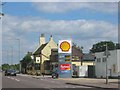
Three Horseshoes and the Garage at Smallford
The pub shows up on the out of date map so I thought it worthwhile including as a record.
Image: © Jack Hill
Taken: 7 Aug 2005
0.14 miles
2
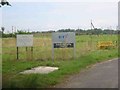
BT testing ground for overhead installations.
The facility appears almost to be forgotten. witness the next photo.
Image: © Jack Hill
Taken: 12 Aug 2005
0.15 miles
3
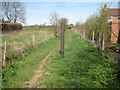
Colney Heath: Bridleway to Coopers Green Lane (1)
Several of the bridleways in this area of Colney Heath have these large bored vertical metal pipes at their starts.
Image: © Nigel Cox
Taken: 12 Apr 2015
0.16 miles
4
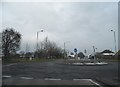
Mini-roundabout on Hatfield Road, Smallford
This is approaching the border between St Albans and Hatfield.
Image: © David Howard
Taken: 11 Apr 2013
0.18 miles
5
Smallford: Site of the former St Albans Radio Station
This is a repeat view of Stan's Image] and sadly his worst fears about the loss of this building, expressed in the grid square discussion page, have long since come true. The building is gone, and has evidently been gone for some time, and only the pair of coniferous trees at the entrance, the vegetation of which can be glimpsed on either side in Stan's image, remain.
Image: © Nigel Cox
Taken: 12 Apr 2015
0.19 miles
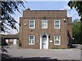
6
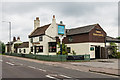
Three Horseshoes
Early 18th century pub on Hatfield Road. Grade II listed - see www.historicengland.org.uk/listing/the-list/list-entry/1172839.
Image: © Ian Capper
Taken: 14 Jun 2014
0.20 miles
7
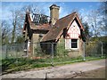
Smallford: Fire-damaged East Lodge at Oaklands
Very sadly this little lodge building on East Drive, that dates back to 1877, has recently suffered severe fire damage. Searching the internet for more information the photographer found a recent estate agent's "For sale" brochure indicating that it was being marketed, prior to the fire, but in a derelict state needing complete refurbishment, for £625,000.
Image: © Nigel Cox
Taken: 12 Apr 2015
0.20 miles
8
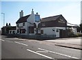
Smallford: Three Horseshoes
1930's Ordnance Survey maps show this public house as just The Horsehsoes. It is a Grade II Listed Building, the early timber framed parts of which date from the early 18th Century. The pub's website is here http://www.vintageinn.co.uk/thethreehorseshoesstalbans/
Image: © Nigel Cox
Taken: 12 Apr 2015
0.20 miles
9
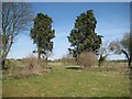
St Albans Radio Station, Smallford
St Albans Radio Station was a point to point radio link run by the Post Office. It was opened in 1926 and closed in the 1960s. It was subsequently used as a GPO/BT testing ground and at the time this picture was taken (July 08) was almost derelict and awaiting redevelopment. It was used secretly in WW2 as a listening station feeding coded messages to Bletchley Park for decryption. It was the first station to intercept German radio teleprinter transmissions which were used for their most secret messages, but using the Colossus computer they were decrypted at Bletchley and were a major influence on the outcome of the war.
Image: © Stan Ames
Taken: 24 Jul 2008
0.21 miles
10
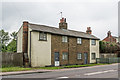
614/616 Hatfield Road
Terrace of houses in Smallford. Although undated, they appear on the 1873-79 revision of the 6 inch map (published in 1883), and so dates from before then.
Image: © Ian Capper
Taken: 14 Jun 2014
0.21 miles