IMAGES TAKEN NEAR TO
Sovereign Park, ST. ALBANS, AL4 0FJ
Introduction
This page details the photographs taken nearby to Sovereign Park, AL4 0FJ by members of the Geograph project.
The Geograph project started in 2005 with the aim of publishing, organising and preserving representative images for every square kilometre of Great Britain, Ireland and the Isle of Man.

There are currently over 7.5m images from over14,400 individuals and you can help contribute to the project by visiting https://www.geograph.org.uk
Image Map (Loading...)


Getting Data...Please wait
Leaflet Map data © OpenStreetMap
Images are licensed for reuse under creativecommons.org/licenses/by-sa/2.0
Notes
- Clicking on the map will re-center to the selected point.
- The higher the marker number, the further away the image location is from the centre of the postcode.
Image Listing (32 Images Found)
Images are licensed for reuse under creativecommons.org/licenses/by-sa/2.0
Image
Details
Distance
1
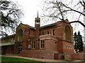
Church, now used as art centre
The church at TL175068 has been converted into an arts centre / theatre sort of thing.
Image: © Rob Hinkley
Taken: 10 Apr 2005
0.05 miles
2
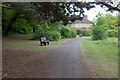
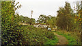
Hill End garden of rest looking eastwards
Image: © Robert Eva
Taken: 6 May 2017
0.10 miles
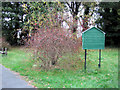
4
Hill End Garden of Rest - Hill End Hospital Cemetery, St Albans
Nearly two years after I took Image things have started to happen. A Notice has appeared!
Hillfield Park is actually Hill End - but history accuracy means nothing to "politically correct" developers who wanted to hide the history in case 0.001% of potential customers might be put off by the name!
Image: © Chris Reynolds
Taken: 30 Apr 2009
0.11 miles
5
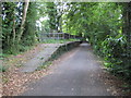
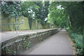
St Albans: Former Hill End railway station
The Great Northern Railway opened this station on their St Albans to Hatfield line in 1899 to serve the then new Hertfordshire County Mental Hospital. The station had a couple of sidings on its south side where a mobile home park is now, while a longer siding ran from a point west of the station into the hospital itself in order to deliver coal and other goods. The station closed along with passenger facilities on the rest of the line in 1951.
This is the same view as Barry's Image Photographs published elsewhere on the internet indicate that the railings arrived between 2004 and 2006, no doubt to alleviate some perceived health and safety risk. Meanwhile the platform edge remains unprotected to the unwary pedestrian...
The railway trackbed now forms the Alban Way and a section of National Cycle Network Route 61.
Image: © Nigel Cox
Taken: 24 Jun 2009
0.11 miles
6
Samuel Adrian Lomas's grave, Hill End Hospital Cemetery, St Albans
This stone carries the name of Samuel Adrian Lomas - who died on the 24th November 1901 aged 63. For general view showing location Image
Image: © Chris Reynolds
Taken: 7 Nov 2007
0.11 miles
7
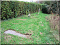
The Grave Stones in Hill End Hospital Cemetery, St Albans
The nearest stone is for of Samuel Adrian Lomas - who died on the 24th November 1901 aged 63.
See Image
See also Image
Image: © Chris Reynolds
Taken: 7 Nov 2007
0.11 miles
8
At the Entrance - Hill End Hospital Cemetery, St Albans
Image: © Chris Reynolds
Taken: 7 Nov 2007
0.12 miles
9
Site of Hill End station
View off Hill End Lane (St Albans) towards Hatfield: ex-GNR Hatfield - St Albans (London Road) branch, closed to passengers 1/10/51, to goods 5/10/64.
Image: © Ben Brooksbank
Taken: 10 Oct 1993
0.12 miles
10
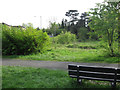
The Seat has been repaired at Hill End Hospital Cemetery, St Albans
Since the earlier visit the broken seats have been repaired (see Image) and at least part of the overgrown area has been cut back (see Image)
Image: © Chris Reynolds
Taken: 30 Apr 2009
0.12 miles