IMAGES TAKEN NEAR TO
Sleapshyde, ST. ALBANS, AL4 0FH
Introduction
This page details the photographs taken nearby to Sleapshyde, AL4 0FH by members of the Geograph project.
The Geograph project started in 2005 with the aim of publishing, organising and preserving representative images for every square kilometre of Great Britain, Ireland and the Isle of Man.

There are currently over 7.5m images from over14,400 individuals and you can help contribute to the project by visiting https://www.geograph.org.uk
Image Map (Loading...)


Getting Data...Please wait
Leaflet Map data © OpenStreetMap
Images are licensed for reuse under creativecommons.org/licenses/by-sa/2.0
Notes
- Clicking on the map will re-center to the selected point.
- The higher the marker number, the further away the image location is from the centre of the postcode.
Image Listing (17 Images Found)
Images are licensed for reuse under creativecommons.org/licenses/by-sa/2.0
Image
Details
Distance
1
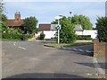
Sleapshyde
Up until the 1930s and the building of the North Orbital Road nearby, Sleapshyde was just an isolated rural hamlet with a farm, a pub, a chapel, and a few cottages. Since then it has expanded considerably. This green is the historical centre of the hamlet. The grey metal post in the centre carries a nameboard with "Sleap's Hyde", while old Ordnance Survey maps from the 1870s up to the 1930s describe the hamlet as Sleepshyde.
Image: © Nigel Cox
Taken: 24 Jun 2009
0.05 miles
2
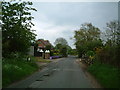
Sleapshyde
Marked as Sleepshyde on the old map. This picture shows Sleapshyde Lane.
Image: © Ray Stanton
Taken: 7 May 2006
0.06 miles
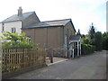
3
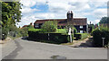
Part of old Sleapshyde
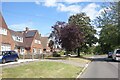
Sleapshyde has two distinct parts, the original small hamlet at this end and 20th century suburban style housing on the west side.
Image: © Des Blenkinsopp
Taken: 25 Aug 2024
0.06 miles
4
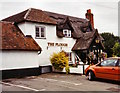
The Plough, Sleapshyde
This pub features in a 1967 episode of the ITC show The Champions (episode was The Night People)
Image: © Duncan Lilly
Taken: 26 Jun 2004
0.06 miles
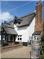
5
Sleapshyde Methodist Church
Sleapshyde Methodist Church was originally a Wesleyan Methodist Chapel built around 1840. It is tucked away down a no through road and opposite The Plough public house.
Image: © Nigel Cox
Taken: 24 Jun 2009
0.07 miles
6
The Plough, Sleapshyde
In a tiny village at the end of a narrow lane out into fields, The Plough is one of those traditional country pubs that are now too few and far between.
It's difficult to get a good picture during opening hours as the forecourt is used for parking, but this angled shot from behind the barrels gives an idea of what the pub looks like.
Image: © Des Blenkinsopp
Taken: 25 Aug 2024
0.07 miles
7
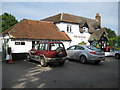
Sleapshyde: The Plough
Taken almost 5 years to the day after Duncan's Image The Plough shows little change. It is one of a select group of public houses that warrant their own PH abbreviation on the Ordnance Survey's 1:50,000 scale mapping.
Image: © Nigel Cox
Taken: 24 Jun 2009
0.08 miles

9
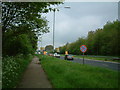
North Orbital Road
The A414 looking towards Hatfield
Image: © Ray Stanton
Taken: 7 May 2006
0.13 miles
10
Sleapshyde Lane
The 20th century extension to the old hamlet of Sleapshyde.
Image: © Des Blenkinsopp
Taken: 25 Aug 2024
0.17 miles