IMAGES TAKEN NEAR TO
Chestnut Drive, ST. ALBANS, AL4 0ES
Introduction
This page details the photographs taken nearby to Chestnut Drive, AL4 0ES by members of the Geograph project.
The Geograph project started in 2005 with the aim of publishing, organising and preserving representative images for every square kilometre of Great Britain, Ireland and the Isle of Man.

There are currently over 7.5m images from over14,400 individuals and you can help contribute to the project by visiting https://www.geograph.org.uk
Image Map (Loading...)


Getting Data...Please wait
Leaflet Map data © OpenStreetMap
Images are licensed for reuse under creativecommons.org/licenses/by-sa/2.0
Notes
- Clicking on the map will re-center to the selected point.
- The higher the marker number, the further away the image location is from the centre of the postcode.
Image Listing (4 Images Found)
Images are licensed for reuse under creativecommons.org/licenses/by-sa/2.0
Image
Details
Distance
1
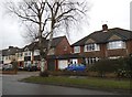
Houses on Beechwood Avenue, Marshalswick
Image: © David Howard
Taken: 28 Feb 2017
0.12 miles
2
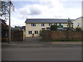
Mount Carmel School, Marshalswick
It has recently been painted over the red bricks.
Image: © David Howard
Taken: 28 May 2015
0.16 miles
3
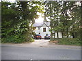
House on Marshalswick Lane
The house has either had new doors or windows or been entirely rebuilt, it is similar to the one which was there previously so hard to be sure.
Image: © David Howard
Taken: 28 May 2015
0.16 miles
4
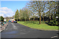
Green space at St John's Court
A planned part of the development.
Image: © Bill Boaden
Taken: 27 Feb 2020
0.22 miles