IMAGES TAKEN NEAR TO
Princess Diana Drive, ST. ALBANS, AL4 0DF
Introduction
This page details the photographs taken nearby to Princess Diana Drive, AL4 0DF by members of the Geograph project.
The Geograph project started in 2005 with the aim of publishing, organising and preserving representative images for every square kilometre of Great Britain, Ireland and the Isle of Man.

There are currently over 7.5m images from over14,400 individuals and you can help contribute to the project by visiting https://www.geograph.org.uk
Image Map
Images are licensed for reuse under creativecommons.org/licenses/by-sa/2.0
Notes
- Clicking on the map will re-center to the selected point.
- The higher the marker number, the further away the image location is from the centre of the postcode.
Image Listing (39 Images Found)
Images are licensed for reuse under creativecommons.org/licenses/by-sa/2.0
Image
Details
Distance
1
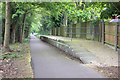
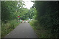
Hill End station platform looking towards Hill End Lane
Part of the Alban Way route from St Albans to Hatfield
Image: © Robert Eva
Taken: 6 May 2017
0.03 miles
2
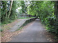
St Albans: Former Hill End railway station
The Great Northern Railway opened this station on their St Albans to Hatfield line in 1899 to serve the then new Hertfordshire County Mental Hospital. The station had a couple of sidings on its south side where a mobile home park is now, while a longer siding ran from a point west of the station into the hospital itself in order to deliver coal and other goods. The station closed along with passenger facilities on the rest of the line in 1951.
This is the same view as Barry's Image Photographs published elsewhere on the internet indicate that the railings arrived between 2004 and 2006, no doubt to alleviate some perceived health and safety risk. Meanwhile the platform edge remains unprotected to the unwary pedestrian...
The railway trackbed now forms the Alban Way and a section of National Cycle Network Route 61.
Image: © Nigel Cox
Taken: 24 Jun 2009
0.04 miles
4
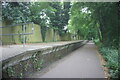
Site of Hill End station
View off Hill End Lane (St Albans) towards Hatfield: ex-GNR Hatfield - St Albans (London Road) branch, closed to passengers 1/10/51, to goods 5/10/64.
Image: © Ben Brooksbank
Taken: 10 Oct 1993
0.05 miles
5
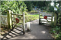
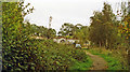
Alban Way crosses Hill End Lane
An old railway line between Hatfield and St Albans is now a cycleway, The Alban Way. It crosses a local road here through decorative old fashioned level crossing style gates.
Image: © Des Blenkinsopp
Taken: 25 Aug 2024
0.08 miles
7
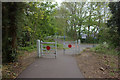
Hill End Lane crossing
Level-crossing style gates where the Alban Way crosses Hill End Lane.
Image: © Robert Eva
Taken: 6 May 2017
0.09 miles
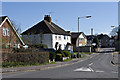
8
Marconi Way, St Albans
Radio pioneer Guglielmo Marconi founded an electronics manufacturing company which was a major employer in St Albans before being sold off to other businesses.
History on https://en.wikipedia.org/wiki/Marconi_Instruments
Image: © Des Blenkinsopp
Taken: 25 Aug 2024
0.09 miles
9
Marconi Way
Cul de sac off Hill End Lane
Image: © Ian Capper
Taken: 20 Apr 2013
0.10 miles
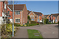
10
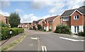
Hill End Lane
Housing in Hill End Laneby its junction with Marconi Way.
Image: © Ian Capper
Taken: 20 Apr 2013
0.13 miles