IMAGES TAKEN NEAR TO
Lynsey Close, ST. ALBANS, AL3 7PW
Introduction
This page details the photographs taken nearby to Lynsey Close, AL3 7PW by members of the Geograph project.
The Geograph project started in 2005 with the aim of publishing, organising and preserving representative images for every square kilometre of Great Britain, Ireland and the Isle of Man.

There are currently over 7.5m images from over14,400 individuals and you can help contribute to the project by visiting https://www.geograph.org.uk
Image Map (17 Images)


Getting Data...Please wait
Leaflet Map data © OpenStreetMap
Images are licensed for reuse under creativecommons.org/licenses/by-sa/2.0
Notes
- Clicking on the map will re-center to the selected point.
- The higher the marker number, the further away the image location is from the centre of the postcode.
Image Listing (17 Images Found)
Images are licensed for reuse under creativecommons.org/licenses/by-sa/2.0
Image
Details
Distance
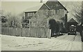
1
Chesterton, Bettespol Meadows, Redbourn in 1947
My pram in the garden, photographed by my father George Baker.
Image: © George Baker
Taken: Unknown
0.11 miles
2
Chesterton, Bettespol Meadows, Redbourn in 1947
Photographed by my father George Baker. Snow might be lying on the ground but two windows were wide open, probably to air my nursery as they belonged to my bedroom.
Image: © George Baker
Taken: Unknown
0.12 miles
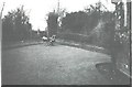
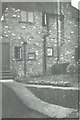
3
Chesterton, Bettespol Meadows, Redbourn in 1947
As seen from Blackhorse Lane and photographed by my father George Baker
Image: © George Baker
Taken: Unknown
0.12 miles
4
Chesterton, Bettespol Meadows, Redbourn in 1947
The path to the front door photographed by my father George Baker
Image: © George Baker
Taken: Unknown
0.12 miles
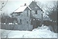
5
Chesterton, Bettespol Meadows, Redbourn in 1947
The back of the house photographed by my father George Baker
Image: © George Baker
Taken: Unknown
0.12 miles
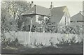
6
Chesterton, Bettespol Meadows, Redbourn in 1947
View taken by my father George Baker of the house in which I was born in November 1946
Image: © George Baker
Taken: Unknown
0.13 miles
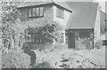
7
Chesterton, 1 Bettespol Meadows, Redbourn in 1970
This is the house where I was born in November 1946. My parents had moved here from Framlingham Court, Ipswich in 1945 see http://www.geograph.org.uk/photo/1348289 and we moved to Appledore, 35 Montague Road, Berkhamsted in 1951 see http://www.geograph.org.uk/photo/1782875
Image: © John Baker
Taken: 16 May 1970
0.14 miles
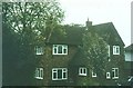
8
Houses in Bettespol Meadows, Redbourn in 1970
The houses are fairly near the house called Chesterton.
Image: © John Baker
Taken: 16 May 1970
0.14 miles
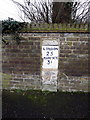
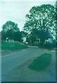
10

Old Milestone by Dunstable Road, Redbourn parish
Carved stone post by the UC road, in parish of REDBOURN (ST ALBANS District), Dunstable Road opposite Bylands House, in high brick wall, on West side of road. Dunstable stone, erected by the Dunstable turnpike trust in the 19th century.
Inscription reads:-
LONDON
25
MARKYATE
3½
Carved bench mark on lower face.
Milestone Society National ID: HE_LH25.
Image: © MW Hallett
Taken: 23 Mar 2003
0.15 miles