IMAGES TAKEN NEAR TO
Dunstable Road, ST. ALBANS, AL3 7PR
Introduction
This page details the photographs taken nearby to Dunstable Road, AL3 7PR by members of the Geograph project.
The Geograph project started in 2005 with the aim of publishing, organising and preserving representative images for every square kilometre of Great Britain, Ireland and the Isle of Man.

There are currently over 7.5m images from over14,400 individuals and you can help contribute to the project by visiting https://www.geograph.org.uk
Image Map (Loading...)


Getting Data...Please wait
Leaflet Map data © OpenStreetMap
Images are licensed for reuse under creativecommons.org/licenses/by-sa/2.0
Notes
- Clicking on the map will re-center to the selected point.
- The higher the marker number, the further away the image location is from the centre of the postcode.
Image Listing (17 Images Found)
Images are licensed for reuse under creativecommons.org/licenses/by-sa/2.0
Image
Details
Distance
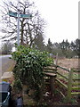
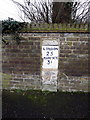
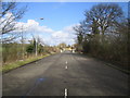
6

Old Milestone by Dunstable Road, Redbourn parish
Carved stone post by the UC road, in parish of REDBOURN (ST ALBANS District), Dunstable Road opposite Bylands House, in high brick wall, on West side of road. Dunstable stone, erected by the Dunstable turnpike trust in the 19th century.
Inscription reads:-
LONDON
25
MARKYATE
3½
Carved bench mark on lower face.
Milestone Society National ID: HE_LH25.
Image: © MW Hallett
Taken: 23 Mar 2003
0.07 miles
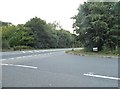
8
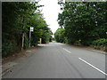
The A5183 heading towards Redbourn
By the junction of Luton Lane
Image: © David Howard
Taken: 27 Sep 2011
0.15 miles
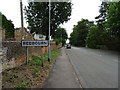
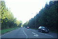
9
Redbourn: Dunstable Road
Once the Roman Watling Street, then the arterial A5, then Dunstable Road, and now nothing more than the dead end of the road leading north out of Redbourn.
Image: © Nigel Cox
Taken: 25 Mar 2006
0.17 miles