IMAGES TAKEN NEAR TO
Tassell Hall, ST. ALBANS, AL3 7JD
Introduction
This page details the photographs taken nearby to Tassell Hall, AL3 7JD by members of the Geograph project.
The Geograph project started in 2005 with the aim of publishing, organising and preserving representative images for every square kilometre of Great Britain, Ireland and the Isle of Man.

There are currently over 7.5m images from over14,400 individuals and you can help contribute to the project by visiting https://www.geograph.org.uk
Image Map
Images are licensed for reuse under creativecommons.org/licenses/by-sa/2.0
Notes
- Clicking on the map will re-center to the selected point.
- The higher the marker number, the further away the image location is from the centre of the postcode.
Image Listing (9 Images Found)
Images are licensed for reuse under creativecommons.org/licenses/by-sa/2.0
Image
Details
Distance
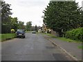
2
Nicholl's Close
A crescent of semi-detached houses, originally council houses in the 1950s.
Image: © M J Richardson
Taken: 4 Sep 2008
0.12 miles
3
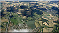
The M1 motorway from the air
The north side of Redbourn is in the foreground, with Hertfordshire County Showground beyond.
Image: © Thomas Nugent
Taken: 17 Jul 2024
0.14 miles
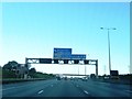
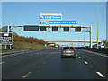
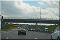
4
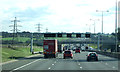
M1 near Redbourn
Heading south towards London.
Image: © JThomas
Taken: 5 Mar 2012
0.19 miles