IMAGES TAKEN NEAR TO
Brooke End, ST. ALBANS, AL3 7GD
Introduction
This page details the photographs taken nearby to Brooke End, AL3 7GD by members of the Geograph project.
The Geograph project started in 2005 with the aim of publishing, organising and preserving representative images for every square kilometre of Great Britain, Ireland and the Isle of Man.

There are currently over 7.5m images from over14,400 individuals and you can help contribute to the project by visiting https://www.geograph.org.uk
Image Map
Images are licensed for reuse under creativecommons.org/licenses/by-sa/2.0
Notes
- Clicking on the map will re-center to the selected point.
- The higher the marker number, the further away the image location is from the centre of the postcode.
Image Listing (54 Images Found)
Images are licensed for reuse under creativecommons.org/licenses/by-sa/2.0
Image
Details
Distance
1
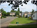
New Housing called The Park, Redbourn
The design is simple without bits planted on.
Image: © Jack Hill
Taken: 23 Aug 2005
0.10 miles
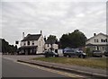
2
Redbourn Museum
This was the Silk Mill House, the house of the Manager of Woollam's silk mill, built in 1857 and in use as such until 1938. It was then used by Brooke Bond Tea Company, who had a tea packaging factory in the village. The house was given to the village when they left in 1999. Unfortunately, the museum was not open when I was there.
Image: © M J Richardson
Taken: 4 Sep 2008
0.12 miles
4
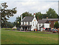
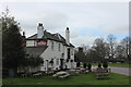
Cricketer's Pub, Redbourn
Viewed from the Common
Image: © Dave Skinner
Taken: 26 Aug 2006
0.12 miles
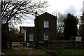
8
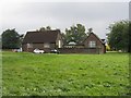
The Old School
Now housing a firm of accountants, this was originally one of the two Redbourn primary schools. In my day [1940s] all infants [years 1-3] went to the right hand building. At year 4 the girls simply moved to the building on the left. The boys were sent off across the Common to the Boys School for years 4-6. Then it was secondary school in St Albans.
Image: © M J Richardson
Taken: 4 Sep 2008
0.13 miles
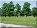
9
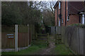
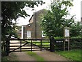
Path from Church End to Hemel Hempsted road
Image: © Robert Eva
Taken: 7 Mar 2017
0.13 miles