IMAGES TAKEN NEAR TO
Crouch Hall Lane, ST. ALBANS, AL3 7EQ
Introduction
This page details the photographs taken nearby to Crouch Hall Lane, AL3 7EQ by members of the Geograph project.
The Geograph project started in 2005 with the aim of publishing, organising and preserving representative images for every square kilometre of Great Britain, Ireland and the Isle of Man.

There are currently over 7.5m images from over14,400 individuals and you can help contribute to the project by visiting https://www.geograph.org.uk
Image Map
Images are licensed for reuse under creativecommons.org/licenses/by-sa/2.0
Notes
- Clicking on the map will re-center to the selected point.
- The higher the marker number, the further away the image location is from the centre of the postcode.
Image Listing (59 Images Found)
Images are licensed for reuse under creativecommons.org/licenses/by-sa/2.0
Image
Details
Distance
1
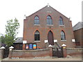
Redbourn Methodist Church, Herts
Situated in North Common AL3 7BU, this church dates from 1876 and is one of several Methodist churches in the West Hertfordshire & Borders Circuit. Services take place here each Sunday at 10.30am, whilst activities are held during the week.
Image: © David Hillas
Taken: 9 May 2017
0.05 miles
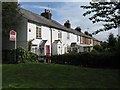
2
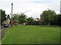
A surprise in Lamb Lane
A small patch of land a few metres from the centre of Redbourn which, unlike many other patches, has remained unbuilt upon. It once supported a row of four small two-up/two-down houses, each with outside privy, and a large garden at the end.
Image: © M J Richardson
Taken: 4 Sep 2008
0.06 miles
3
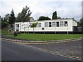
Redbourn Library
Many years earlier, in the 1950s, the library was in Fish Street, in what I think had been an old chapel.
Image: © M J Richardson
Taken: 4 Sep 2008
0.08 miles
4
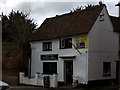
Redbourn barber shop
This looks like one of the older buildings in the High St
Image: © Robert Eva
Taken: 7 Mar 2017
0.09 miles
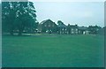
5
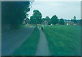
North Common, Redbourn in 1970
In the middle distance is the Wesleyan chapel and in the far distance is Cumberland House.
Image: © John Baker
Taken: 20 May 1970
0.10 miles
6
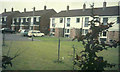
Holts Meadow, Redbourn in 1970
These houses were built on land formerly belonging to Image
Image: © John Baker
Taken: 16 May 1970
0.10 miles
7
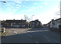
Dunstable Road, Redbourn
At the junction with High Street & Harpenden Lane near Redbourn Fire Station
Image: © Geographer
Taken: 19 Jan 2016
0.12 miles
8
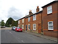
Shepherds Row
A terrace of small village houses on a cut-through alley from Lamb Lane to the High Street.
Image: © M J Richardson
Taken: 4 Sep 2008
0.12 miles
9
Wesleyan Chapel, North Common, Redbourn in 1970
Image: © John Baker
Taken: 16 May 1970
0.12 miles