IMAGES TAKEN NEAR TO
Harpenden Road, ST. ALBANS, AL3 6JG
Introduction
This page details the photographs taken nearby to Harpenden Road, AL3 6JG by members of the Geograph project.
The Geograph project started in 2005 with the aim of publishing, organising and preserving representative images for every square kilometre of Great Britain, Ireland and the Isle of Man.

There are currently over 7.5m images from over14,400 individuals and you can help contribute to the project by visiting https://www.geograph.org.uk
Image Map
Images are licensed for reuse under creativecommons.org/licenses/by-sa/2.0
Notes
- Clicking on the map will re-center to the selected point.
- The higher the marker number, the further away the image location is from the centre of the postcode.
Image Listing (5 Images Found)
Images are licensed for reuse under creativecommons.org/licenses/by-sa/2.0
Image
Details
Distance
1
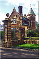
Lodge, Childwickbury Estate, Harpenden Road (1897)
Image: © Jim Osley
Taken: 1 Sep 2012
0.11 miles
2
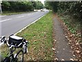
This is route 6?!
The standard of UK bicycle traffic infrastructure - a disgrace. Beside the A1081
Image: © David Lally
Taken: 5 Oct 2019
0.19 miles
4
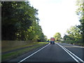
Harpenden Road at the entrance to Woolam's Playing Fields
Image: © David Howard
Taken: 25 Jul 2017
0.21 miles
5
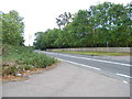
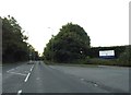
Harpenden Road, Childwick Green
At the entrance to Cheapside Farm
Image: © David Howard
Taken: 18 Sep 2012
0.22 miles