IMAGES TAKEN NEAR TO
Sandridgebury Lane, ST. ALBANS, AL3 6DD
Introduction
This page details the photographs taken nearby to Sandridgebury Lane, AL3 6DD by members of the Geograph project.
The Geograph project started in 2005 with the aim of publishing, organising and preserving representative images for every square kilometre of Great Britain, Ireland and the Isle of Man.

There are currently over 7.5m images from over14,400 individuals and you can help contribute to the project by visiting https://www.geograph.org.uk
Image Map (Loading...)


Getting Data...Please wait
Leaflet Map data © OpenStreetMap
Images are licensed for reuse under creativecommons.org/licenses/by-sa/2.0
Notes
- Clicking on the map will re-center to the selected point.
- The higher the marker number, the further away the image location is from the centre of the postcode.
Image Listing (21 Images Found)
Images are licensed for reuse under creativecommons.org/licenses/by-sa/2.0
Image
Details
Distance
1
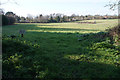
Private field on the edge of St Albans
Houses lining Harpenden Road can be seen on the other side of the field.
Image: © Bill Boaden
Taken: 29 Feb 2020
0.05 miles
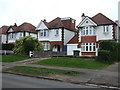
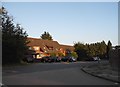
3

St Albans Girls School, Sandridgebury Lane
The large area of hard paving is not very welcoming. A Porch to the front doors would be a useful addition. But alas the money !!
Image: © Jack Hill
Taken: 19 Aug 2005
0.12 miles
5
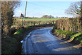
Bend on Sandridgebury Lane
The sign says the road is liable to flooding, with the ditch to the left operating smoothly. However, round the bend, see this view Image
Image: © Bill Boaden
Taken: 29 Feb 2020
0.13 miles
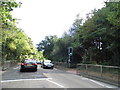
6
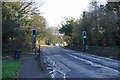
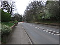
Pedestrian crossing on Harpenden Road
The A1081 is heading towards the centre of St Albans.
Image: © Bill Boaden
Taken: 29 Feb 2020
0.14 miles
7
New Greens Avenue at the junction of Partridge Road
Image: © David Howard
Taken: 25 Jul 2017
0.15 miles
8
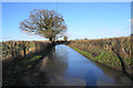
Flood on Sandbridgebury Lane
Round the bend from Image, and this is as far as I will get today on foot.
Image: © Bill Boaden
Taken: 29 Feb 2020
0.15 miles
9
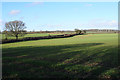
Farmland north of St Albans
The route of Sandridgebury Lane can be seen between the hedgerows.
Image: © Bill Boaden
Taken: 29 Feb 2020
0.16 miles
10
Harpenden Road (A1081)
Looking north east.
Image: © JThomas
Taken: 18 Mar 2017
0.19 miles