IMAGES TAKEN NEAR TO
Beech Tree Lane, ST. ALBANS, AL3 6AR
Introduction
This page details the photographs taken nearby to Beech Tree Lane, AL3 6AR by members of the Geograph project.
The Geograph project started in 2005 with the aim of publishing, organising and preserving representative images for every square kilometre of Great Britain, Ireland and the Isle of Man.

There are currently over 7.5m images from over14,400 individuals and you can help contribute to the project by visiting https://www.geograph.org.uk
Image Map (Loading...)


Getting Data...Please wait
Leaflet Map data © OpenStreetMap
Images are licensed for reuse under creativecommons.org/licenses/by-sa/2.0
Notes
- Clicking on the map will re-center to the selected point.
- The higher the marker number, the further away the image location is from the centre of the postcode.
Image Listing (2 Images Found)
Images are licensed for reuse under creativecommons.org/licenses/by-sa/2.0
Image
Details
Distance
1
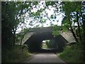
Bridge over Beechtree Lane
The design of this bridge carrying the M10 just before it merges with the M1 is typical of the period with the rustications
Image: © Jack Hill
Taken: 12 Aug 2005
0.02 miles
2
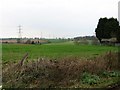
Farmland, farmland...
Looking NW from the track at TL107064 by Hill End Farm (buildings at right).
Image: © Rob Hinkley
Taken: 26 Mar 2005
0.13 miles