IMAGES TAKEN NEAR TO
Gorhambury, ST. ALBANS, AL3 6AH
Introduction
This page details the photographs taken nearby to AL3 6AH by members of the Geograph project.
The Geograph project started in 2005 with the aim of publishing, organising and preserving representative images for every square kilometre of Great Britain, Ireland and the Isle of Man.

There are currently over 7.5m images from over14,400 individuals and you can help contribute to the project by visiting https://www.geograph.org.uk
Image Map
Images are licensed for reuse under creativecommons.org/licenses/by-sa/2.0
Notes
- Clicking on the map will re-center to the selected point.
- The higher the marker number, the further away the image location is from the centre of the postcode.
Image Listing (2 Images Found)
Images are licensed for reuse under creativecommons.org/licenses/by-sa/2.0
Image
Details
Distance
1
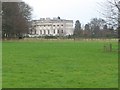
Gorhambury House
The Gorhambury estate is private, but the owners allow the hoi-polloi to walk and cycle on their roads.
Photo: Looking NE from the road at about TL111076.
Image: © Rob Hinkley
Taken: 26 Mar 2005
0.02 miles
2
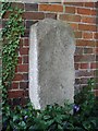
Old Milestone by Gorhambury House, St Michael's parish
Carved stone post, which was on the A5, in parish of ST MICHAEL (ST ALBANS District), now by the dairy, North of Gorhambury House, Bluehouse Hill, against brick wall in garden (Maybe a Terminus Stone), on North side of road. Erected by the Pondyards (St Albans) & Barnet turnpike trust in the 19th century.
Inscription reads on two sides:-
: This (?) from London 22 miles to 6 furlongs 12 poles : : This (?) from London 22 miles to 6 furlongs 12 poles :
Carved benchmark on right face.
Grade II listed.
List Entry Number: 1102916 https://historicengland.org.uk/listing/the-list/list-entry/1102916
Milestone Society National ID: HE_LHG22.
Image: © n/a
Taken: Unknown
0.04 miles