IMAGES TAKEN NEAR TO
Marshall Avenue, ST. ALBANS, AL3 5HS
Introduction
This page details the photographs taken nearby to Marshall Avenue, AL3 5HS by members of the Geograph project.
The Geograph project started in 2005 with the aim of publishing, organising and preserving representative images for every square kilometre of Great Britain, Ireland and the Isle of Man.

There are currently over 7.5m images from over14,400 individuals and you can help contribute to the project by visiting https://www.geograph.org.uk
Image Map (Loading...)


Getting Data...Please wait
Leaflet Map data © OpenStreetMap
Images are licensed for reuse under creativecommons.org/licenses/by-sa/2.0
Notes
- Clicking on the map will re-center to the selected point.
- The higher the marker number, the further away the image location is from the centre of the postcode.
Image Listing (29 Images Found)
Images are licensed for reuse under creativecommons.org/licenses/by-sa/2.0
Image
Details
Distance
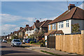
1
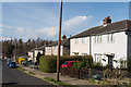
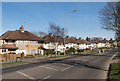
Marshall Avenue
1930s housing between Sandridge Road and Beech Road. The trees in the background mark to the line of Beech Bottom Dyke (see Image).
Image: © Ian Capper
Taken: 15 Mar 2014
0.03 miles
2
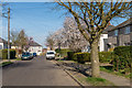
Watson Avenue
1930s housing between Sandridge Road and Beech Road.
Image: © Ian Capper
Taken: 15 Mar 2014
0.10 miles
3
Firbank Road
1930s housing off Beech Road. The trees in the background mark the line of Beech Bottom Dyke (see Image).
Image: © Ian Capper
Taken: 15 Mar 2014
0.11 miles
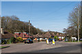
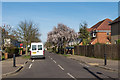
4
Firbank Road bus stop
Served by route 305 towards the town centre.
Image: © Robin Webster
Taken: 14 May 2017
0.11 miles
5
Beech Road
1930s housing on what now serves as a northern ring road to St Albans.
Image: © Ian Capper
Taken: 15 Mar 2014
0.12 miles
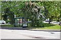
6
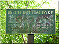
Beach Bottom Dyke explanatory sign
For a view of the dyke, see Image
Image: © Robin Webster
Taken: 14 May 2017
0.13 miles
7
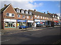
St Albans: Beech Road
Neighbourhood shopping parade on the north side of Beech Road close to the King William IV Junction.
Image: © Nigel Cox
Taken: 17 Oct 2007
0.14 miles
8
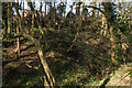
Beech Bottom Dyke
A late Iron Age ditch, approximately 1.4km long, 10m deep and 30 m wide, the main extant part being between the Harpenden Road and the Midland Main Line. A Scheduled Ancient Monument - see http://list.historicengland.org.uk/resultsingle.aspx?uid=1019136.
Image: © Ian Capper
Taken: 15 Mar 2014
0.15 miles
9
Seymour Road
1930s housing between Sandridge Road and Beech Road.
Image: © Ian Capper
Taken: 15 Mar 2014
0.15 miles
10
Watson Avenue
Mainly 1930s housing between Sandridge Road and Beech Road.
Image: © Ian Capper
Taken: 15 Mar 2014
0.15 miles