IMAGES TAKEN NEAR TO
Britton Avenue, ST. ALBANS, AL3 5EL
Introduction
This page details the photographs taken nearby to Britton Avenue, AL3 5EL by members of the Geograph project.
The Geograph project started in 2005 with the aim of publishing, organising and preserving representative images for every square kilometre of Great Britain, Ireland and the Isle of Man.

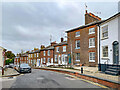
There are currently over 7.5m images from over14,400 individuals and you can help contribute to the project by visiting https://www.geograph.org.uk
Image Map (Loading...)


Getting Data...Please wait
Leaflet Map data © OpenStreetMap
Images are licensed for reuse under creativecommons.org/licenses/by-sa/2.0
Notes
- Clicking on the map will re-center to the selected point.
- The higher the marker number, the further away the image location is from the centre of the postcode.
Image Listing (634 Images Found)
Images are licensed for reuse under creativecommons.org/licenses/by-sa/2.0
Image
Details
Distance
1
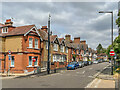
Russell Avenue
Edwardian housing on Russell Avenue, one of a number of roads on area of land sold by the Kentish family in 1899 and marketed as the "Spencer Park Estate".
Image: © Ian Capper
Taken: 20 Jul 2022
0.01 miles
2
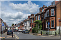
Selby Avenue
Edwardian housing on Selby Avenue, one of a number of roads on area of land sold by the Kentish family in 1899 and marketed as the "Spencer Park Estate".
Image: © Ian Capper
Taken: 8 Jun 2019
0.02 miles
3
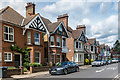
Russell Avenue
Edwardian housing on Russell Avenue, one of a number of roads on area of land sold by the Kentish family in 1899 and marketed as the "Spencer Park Estate".
Image: © Ian Capper
Taken: 8 Jun 2019
0.02 miles
4
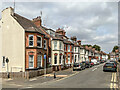
Selby Avenue
Edwardian housing on Selby Avenue, one of a number of roads on area of land sold by the Kentish family in 1899 and marketed as the "Spencer Park Estate".
Image: © Ian Capper
Taken: 20 Jul 2022
0.03 miles
5
Spencer Street
Early 19th Century houses in Spencer Street. The nearest brick fronted building is nos 26 & 28 and beyond (with the small shop front) is no 30. Both buildings are grade II listed - see https://historicengland.org.uk/listing/the-list/list-entry/1103063?section=official-listing and https://historicengland.org.uk/listing/the-list/list-entry/1174513?section=official-listing respectively. Note the raised pavement.
Image: © Ian Capper
Taken: 4 Nov 2021
0.05 miles
6
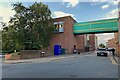
Over Drovers Way, St Albans
The bridge seems to connect the rear of Marks & Spencer to a satellite and a small car park. Drovers Way is modern, providing access to several car parks west of Market Place and St Peter's Street.
Image: © Robin Stott
Taken: 16 Aug 2023
0.05 miles
7
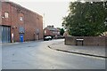
Drovers Way meets Russell Avenue, St Albans
Drovers Way is a modern street, carved from the backland west of St Peter's Street, to access car parks and hotels. Russell Avenue serves a mixture of uses.
Photo number 7624292.
Image: © Robin Stott
Taken: 16 Aug 2023
0.05 miles
8
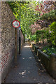
Gombards Alley
Footpath linking Worley Road with Verulam Road, with blue brick paving and a flint and brick wall. The latter was originally the wall of the plot containing Gombards House, a Regency house built in the early 18th Century and demolished in the 1960s for a road scheme that never happened, the site now containing a car park and garages.
Image: © Ian Capper
Taken: 8 Jun 2019
0.06 miles
9
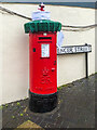
"St Albans Postboxes"
Postbox at the corner of Spencer Street and Verulam Road.
The postbox is one of 50 "yarnbombed" boxes in St Albans and area, part of an initiative known as "St Albans postboxes" started at Christmas 2018. For Christmas 2020, each box topper has a seasonal theme with the year's specific objective being to raise money for two charities, Open Doors and the St Albans and District Foodbank.
Image: © Ian Capper
Taken: 18 Dec 2020
0.06 miles
10
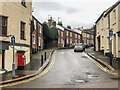
Spencer Street
Looking up Spencer Street from Verulam Road, with buildings dating from the 1860s. For a close up of the "yarnbombed" postbox on the left, see Image
Image: © Ian Capper
Taken: 18 Dec 2020
0.06 miles