IMAGES TAKEN NEAR TO
Harpenden Road, ST. ALBANS, AL3 5AD
Introduction
This page details the photographs taken nearby to Harpenden Road, AL3 5AD by members of the Geograph project.
The Geograph project started in 2005 with the aim of publishing, organising and preserving representative images for every square kilometre of Great Britain, Ireland and the Isle of Man.

There are currently over 7.5m images from over14,400 individuals and you can help contribute to the project by visiting https://www.geograph.org.uk
Image Map (Loading...)


Getting Data...Please wait
Leaflet Map data © OpenStreetMap
Images are licensed for reuse under creativecommons.org/licenses/by-sa/2.0
Notes
- Clicking on the map will re-center to the selected point.
- The higher the marker number, the further away the image location is from the centre of the postcode.
Image Listing (109 Images Found)
Images are licensed for reuse under creativecommons.org/licenses/by-sa/2.0
Image
Details
Distance
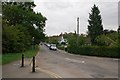
1
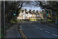
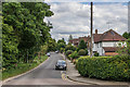
Harpenden Road
The A1081 heading towards the centre of St Albans.
Image: © Bill Boaden
Taken: 29 Feb 2020
0.03 miles
2
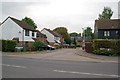
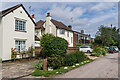
Edmond Beaufort Drive
A small close off Harpenden Road, on the edge of Bernards Heath. It was named after Edmund (or Edmond) Beaufort, Duke of Somerset, who was killed in the First Battle of St Albans in 1455.
Image: © Ian Capper
Taken: 22 Sep 2011
0.04 miles
3
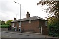
Heath House
An early 19th century grade II listed building - for listing particulars see www.historicengland.org.uk/listing/the-list/list-entry/1103126.
Image: © Ian Capper
Taken: 22 Sep 2011
0.05 miles
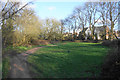
5
St Bernard's Road
Private road off Carlisle Avenue, developed piecemeal over the years.
Image: © Ian Capper
Taken: 19 Aug 2021
0.11 miles
6
Townsend Drive
Road bordering Bernard's Heath (on the left), first marked on the 1898 1:2,500 map as Townsend Road, but with no development. The 1924 edition was similar, but the 1939 edition showed housing as here, and with the current name.
Image: © Ian Capper
Taken: 24 Jul 2020
0.11 miles
7
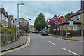
St Albans : Spencer Gate
Looking along Spencer Gate from Sandridge Road.
Image: © Lewis Clarke
Taken: 27 Apr 2019
0.11 miles
8
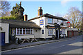
The Jolly Sailor
A familiar sight to anyone who has come into St Albans along Sandpit Lane.
Image: © Bill Boaden
Taken: 29 Feb 2020
0.12 miles
10
Townsend Drive
Developed in the 1930s or so, although the road is shown on late 19th century maps (as Townsend Road). On the left is part of Bernard's Heath.
Image: © Ian Capper
Taken: 22 Sep 2011
0.12 miles