IMAGES TAKEN NEAR TO
Harpenden Road, ST. ALBANS, AL3 5AB
Introduction
This page details the photographs taken nearby to Harpenden Road, AL3 5AB by members of the Geograph project.
The Geograph project started in 2005 with the aim of publishing, organising and preserving representative images for every square kilometre of Great Britain, Ireland and the Isle of Man.

There are currently over 7.5m images from over14,400 individuals and you can help contribute to the project by visiting https://www.geograph.org.uk
Image Map
Images are licensed for reuse under creativecommons.org/licenses/by-sa/2.0
Notes
- Clicking on the map will re-center to the selected point.
- The higher the marker number, the further away the image location is from the centre of the postcode.
Image Listing (166 Images Found)
Images are licensed for reuse under creativecommons.org/licenses/by-sa/2.0
Image
Details
Distance
1
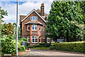
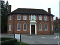
Calverton House
Large Edwardian house at the start of Harpenden Road.
Image: © Ian Capper
Taken: 19 Aug 2021
0.02 miles
2
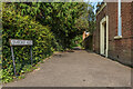
Snatchup Alley
Once a medieval thoroughfare, now a path running behind the former Cricketers pub and the Jolly Sailor, with its role as a road replaced by Stonecross. For many years nameless, research by Kate Morris of the St Albans and Hertfordshire Architectural and Archaeological Society led to the rediscovery of its original name and it was formally renamed in October 2006. The meaning behind the name is uncertain.
Image: © Ian Capper
Taken: 11 Sep 2020
0.03 miles
3
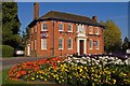
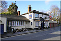
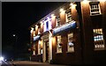
Former Cricketers
There has been a pub called The Cricketers at the head of St Peter's Street, where it divides into Harpenden Road and Stonecross, since the late 19th century, although beer had been sold on the site from at least the middle of that century. The name reflected the former cricket ground on Bernard's Heath, to the north of here. The present building dates from the 1938 and remained in use as a pub until 2005, when it was converted to an Indian Restaurant, called Devdas, but the cricketers sign remains above the front door. It is locally listed.
Image: © Ian Capper
Taken: 2 Oct 2011
0.04 miles
4
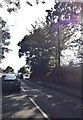
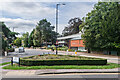
Sandridge Road, Bernards Heath
At the junction with Beech Road
Image: © David Howard
Taken: 22 Jul 2014
0.04 miles
5
The Jolly Sailor
A familiar sight to anyone who has come into St Albans along Sandpit Lane.
Image: © Bill Boaden
Taken: 29 Feb 2020
0.04 miles
6
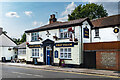
The Jolly Sailor
Pub in Stonecross, dating originally from 1827 with the name thought to refer to William IV, the Sailor King. The current frontage dates a rebuild in 1899, the year painted above the door.
Image: © Ian Capper
Taken: 11 Sep 2020
0.04 miles
8
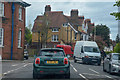
St Albans : Stonecross B651
Heading through St Albans.
Image: © Lewis Clarke
Taken: 27 Apr 2019
0.04 miles
9
Amrit Indian restaurant on Avenue Road, St Albans
Image: © David Howard
Taken: 9 Jan 2022
0.05 miles
10
St Peter's Street
Looking along the northern part of St Peter's Street from outside the former Cricketers pub. On the right is the Seventh-day Adventist church (see Image).
Image: © Ian Capper
Taken: 19 Aug 2021
0.05 miles