IMAGES TAKEN NEAR TO
Smug Oak Lane, ST. ALBANS, AL2 3PN
Introduction
This page details the photographs taken nearby to Smug Oak Lane, AL2 3PN by members of the Geograph project.
The Geograph project started in 2005 with the aim of publishing, organising and preserving representative images for every square kilometre of Great Britain, Ireland and the Isle of Man.

There are currently over 7.5m images from over14,400 individuals and you can help contribute to the project by visiting https://www.geograph.org.uk
Image Map
Images are licensed for reuse under creativecommons.org/licenses/by-sa/2.0
Notes
- Clicking on the map will re-center to the selected point.
- The higher the marker number, the further away the image location is from the centre of the postcode.
Image Listing (9 Images Found)
Images are licensed for reuse under creativecommons.org/licenses/by-sa/2.0
Image
Details
Distance
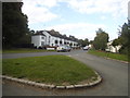
1
The Gate public house
Junction of smug oak lane and station road.
Image: © Ian O'Reilly
Taken: 3 Jul 2011
0.20 miles
2
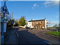
The Gate pub, Smug Oak
See 2005 photo http://www.geograph.org.uk/photo/27902. Here the pub is named the "Toll Gate". I don't know if this is an error or if the pub has actually changed its name.
Image: © Bikeboy
Taken: 19 Jan 2014
0.20 miles
3
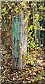
Bricket Wood Common sign
Bricket Wood Common Sign at the junction of Smug Oak Lane and Station Road.
Image: © Brian Smith
Taken: 24 Nov 2011
0.22 miles
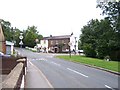
4
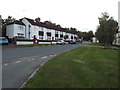
Station Road, Bricket Wood
Station Road in Bricket Wood, taken at dusk on a September evening.
Image: © Malc McDonald
Taken: 26 Sep 2015
0.22 miles
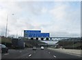
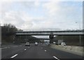
6
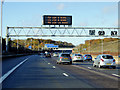
Anticlockwise M25 near to Colney Street,
Image: © David Dixon
Taken: 11 Nov 2018
0.22 miles
7
Drop Lane at the junction of Station Road
This is one of the rare rural Station Roads that still actually has a station, Bricket Wood. The majority went with Beeching or before.
Image: © David Howard
Taken: 2 Sep 2014
0.23 miles