IMAGES TAKEN NEAR TO
Cherry Hill, ST. ALBANS, AL2 3BA
Introduction
This page details the photographs taken nearby to Cherry Hill, AL2 3BA by members of the Geograph project.
The Geograph project started in 2005 with the aim of publishing, organising and preserving representative images for every square kilometre of Great Britain, Ireland and the Isle of Man.

There are currently over 7.5m images from over14,400 individuals and you can help contribute to the project by visiting https://www.geograph.org.uk
Image Map (12 Images)


Getting Data...Please wait
Leaflet Map data © OpenStreetMap
Images are licensed for reuse under creativecommons.org/licenses/by-sa/2.0
Notes
- Clicking on the map will re-center to the selected point.
- The higher the marker number, the further away the image location is from the centre of the postcode.
Image Listing (12 Images Found)
Images are licensed for reuse under creativecommons.org/licenses/by-sa/2.0
Image
Details
Distance
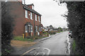
3
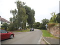
Houses on Ragged Hall Lane, Chiswell Green
The house on the right has recently replaced a bungalow.
Image: © David Howard
Taken: 3 Sep 2015
0.15 miles
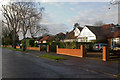
4

Stanley Avenue
1950s bungalows at the junction of Stanley Avenue and Chiswell Green Lane.
Image: © Ian Capper
Taken: 3 Dec 2011
0.20 miles
6
Watford Road, Chiswell Green
About the highest point in Chiswell Green, looking towards Watford. The wooden bus shelter is a common feature in Hertfordshire.
Image: © Ray Stanton
Taken: 12 Jul 2006
0.22 miles
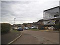
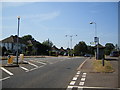
7

Shopping Parade, Chiswell Green
Shopping parade at the junction of Chiswell Green Lane with Watford Road.
Image: © Ian Capper
Taken: 3 Dec 2011
0.23 miles
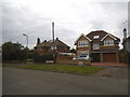
8
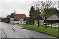
Chiswellgreen Farm
Half-timbered farm buildings which are a bit incongruous with the adjoining housing estates.
Image: © Bill Boaden
Taken: 28 Feb 2020
0.23 miles
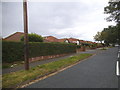
10
Chiswell Green Lane
The very edge of the St Albans conurbation as the lane begins to enter Chiswell Green.
Image: © Bill Boaden
Taken: 28 Feb 2020
0.24 miles