IMAGES TAKEN NEAR TO
Station Terrace, ST. ALBANS, AL2 2PY
Introduction
This page details the photographs taken nearby to Station Terrace, AL2 2PY by members of the Geograph project.
The Geograph project started in 2005 with the aim of publishing, organising and preserving representative images for every square kilometre of Great Britain, Ireland and the Isle of Man.

There are currently over 7.5m images from over14,400 individuals and you can help contribute to the project by visiting https://www.geograph.org.uk
Image Map
Images are licensed for reuse under creativecommons.org/licenses/by-sa/2.0
Notes
- Clicking on the map will re-center to the selected point.
- The higher the marker number, the further away the image location is from the centre of the postcode.
Image Listing (38 Images Found)
Images are licensed for reuse under creativecommons.org/licenses/by-sa/2.0
Image
Details
Distance
1
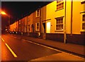
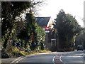
Station Cottages on Watling Street, Park Street
This isn't on two roads, Park Street is the name of the village. Park Street Lane goes from here to Bricket Wood but I am not aware of an actual Park Street as a road name. I'm sure there's a historic explanation if anyone wants to add one here.
Image: © David Howard
Taken: 14 Dec 2013
0.01 miles
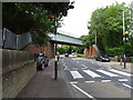
4
Park Street: A5183 Watling Street railway bridge
This skewed bridge carries the single track branch railway line from Watford Junction to St Albans Abbey over the A5183 Watling Street, and marks a change in direction of the otherwise straight Roman Road. Just visible under the bridge on the right hand side is a forward facing Truvelo speed camera. The advantage to the authorities of the use of these cameras is that they can photograph the driver's face as well as the vehicle registration plate.
Image: © Nigel Cox
Taken: 23 Oct 2007
0.06 miles
5

Footpath to A5 from Park Street station
Image: © David Howard
Taken: 29 Jul 2009
0.09 miles
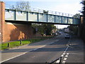
6
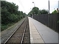
Park Street railway station
Opened in 1858 by the London and North Western Railway on its line from Watford Junction to St. Albans Abbey. View south towards How Wood and Watford Junction.
Image: © Nigel Thompson
Taken: 13 Aug 2012
0.09 miles
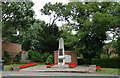
9
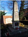
War memorial, Park Street
Unusual in that there is a list of names on the memorial and then a much longer list on the white plaque on the wall behind. There seems to be a distinction between those who died who came from the immediate parish and those from a slightly wider area.
Image: © Bikeboy
Taken: 19 Jan 2014
0.10 miles
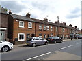
10
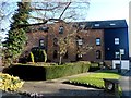
Old mill buildings, Park Street
Now offices.
Image: © Bikeboy
Taken: 19 Jan 2014
0.10 miles