IMAGES TAKEN NEAR TO
White Horse Lane, ST. ALBANS, AL2 1JS
Introduction
This page details the photographs taken nearby to White Horse Lane, AL2 1JS by members of the Geograph project.
The Geograph project started in 2005 with the aim of publishing, organising and preserving representative images for every square kilometre of Great Britain, Ireland and the Isle of Man.

There are currently over 7.5m images from over14,400 individuals and you can help contribute to the project by visiting https://www.geograph.org.uk
Image Map
Images are licensed for reuse under creativecommons.org/licenses/by-sa/2.0
Notes
- Clicking on the map will re-center to the selected point.
- The higher the marker number, the further away the image location is from the centre of the postcode.
Image Listing (76 Images Found)
Images are licensed for reuse under creativecommons.org/licenses/by-sa/2.0
Image
Details
Distance
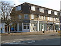
1
The Motorcycle Centre from White Horse Lane
The front is on London Colney High Street
Image: © David Howard
Taken: 6 Aug 2015
0.03 miles
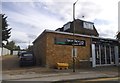
2
Dog-grooming School
An update to my picture Image showing the former Barclay's bank, then a Parish Centre for the nearby Roman Catholic church. It was sold off by the church, and has become a school to teach people to groom dogs. Seems to be quite popular.
Image: © John Webb
Taken: 3 Nov 2017
0.04 miles
3
Our Lady of Walsingham Church Centre - former Barclays Bank
The former Barclays Bank on the corner of London Colney High Street and White Horse Lane. Vacated by the bank around 1990, it was bought by the Roman Catholic parish of Our Lady of Walsingham in 1995 and refurbished as their Church Centre. The church is about 150 yards away in Heseldine Road.
(One of the local schools is advertising their Christmas Fair in a few days time on the railings in front of the Centre!)
Update July 2015: Sold off by the church, the building is now a dog grooming school - see Image for a November 2017 view.
Image: © John Webb
Taken: 1 Dec 2011
0.04 miles
5
Recently opened Co-Op funeral service
Image: © John Webb
Taken: 3 Nov 2017
0.05 miles
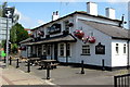
6
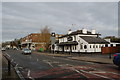
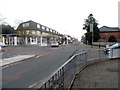
High Street, London Colney, the refurbished White Horse pub
A view of the High Street updated from Image with the "White Horse" pub recently restored back to its original name from the dreadful brewer's name of "Pear and Partridge" which it had borne for some years. This refurbishment is the result of new tenants taking over earlier this year.
Unfortunately the Highways people erected a large sign close to the pub's sign regarding restrictions for lorries over 7.5tonnes as part of an 'experimental' scheme to control such vehicles; it rather spoils the view of the pub, alas.
Image: © John Webb
Taken: 1 Dec 2011
0.05 miles
7
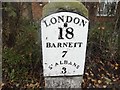
Old Milestone by High Street, London Colney, St Albans parish
Metal plate attached to stone post by the UC road, in parish of London Colney (St Albans District), High Street, at junction with Haseldine Road, in pavement, on West side of road. St Albans plate, erected by the Galley Corner to Lemsford turnpike trust in the 19th century.
Inscription reads:-
LONDON
18
BARNETT
7
Sᵀ ALBANS
3
Grade II listed.
List Entry Number: 1102980 https://historicengland.org.uk/listing/the-list/list-entry/1102980
Milestone Society National ID: HE_LH18
Image: © MW Hallett
Taken: 30 Mar 2003
0.05 miles
8
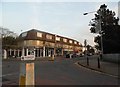
Parade of shops, High Street
An update to Image - the corner shop no longer deals in motor cycles, it has become a new branch of the Co-Op funeral service.
Image: © John Webb
Taken: 3 Nov 2017
0.05 miles
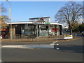
9
London Colney High Street at the junction of Haseldine Road
Image: © David Howard
Taken: 20 Nov 2014
0.06 miles
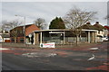
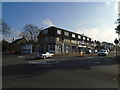
10
Parade of shops on High Street, London Colney
Image: © David Howard
Taken: 20 Nov 2014
0.06 miles