IMAGES TAKEN NEAR TO
Willowside, ST. ALBANS, AL2 1DP
Introduction
This page details the photographs taken nearby to Willowside, AL2 1DP by members of the Geograph project.
The Geograph project started in 2005 with the aim of publishing, organising and preserving representative images for every square kilometre of Great Britain, Ireland and the Isle of Man.

There are currently over 7.5m images from over14,400 individuals and you can help contribute to the project by visiting https://www.geograph.org.uk
Image Map
Images are licensed for reuse under creativecommons.org/licenses/by-sa/2.0
Notes
- Clicking on the map will re-center to the selected point.
- The higher the marker number, the further away the image location is from the centre of the postcode.
Image Listing (117 Images Found)
Images are licensed for reuse under creativecommons.org/licenses/by-sa/2.0
Image
Details
Distance
1
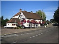
London Colney: The Bull
A fine floral display outside the pub is caught in the early morning sunshine.
As befits its history as the last stagecoach stop before London there are at least seven public houses in London Colney on or very near this road, of which The Bull is one. The road, which was the old A6 and is now just plain old Barnet Road, rises up to London Colney bridge Image in the distance.
Image: © Nigel Cox
Taken: 3 Aug 2007
0.02 miles
2

Bridge over the River Colne, London Colney
Image: © David Howard
Taken: 26 Feb 2009
0.03 miles
3

Road bridge over the River Colne, London Colney
Image: © David Howard
Taken: 26 Feb 2009
0.06 miles
4
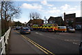
Flooded Green, 1st Feb 2014 (3)
A view of two of the three pumping appliances from Hertfordshire Fire and Rescue Service which attended this incident. They also had a 4-wheel drive pickup truck and a couple of supervisory officers in attendance. In the end their assistance was limited to assisting householders to keep their flood defences in good order.
Image: © John Webb
Taken: 1 Feb 2014
0.06 miles
5

Flooding on 30th October 2000 (1)
Looking across flooded village green to South side and houses in Waterside from footpath on the North side of the bridge. Taken about 4pm, shortly before the water level peaked.
(Compare with Image taken in 2017)
Image: © John Webb
Taken: 30 Oct 2000
0.06 miles
6
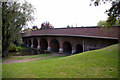
Bridge over the River Colne, London Colney
As seen from Riverside, near St Peter's Church.
The water level is at its usual low level in this picture. See Image for a similar view of the bridge when the water level was over 5ft above the normal level in October 2000.
Image: © Christine Matthews
Taken: 21 Aug 2009
0.07 miles
7

Flooded Green, 1st Feb 2014 (2)
View of houses from bridge seen early afternoon on 1st Feb 2014. Water level was not quite as high as in 2000 - see Image - and I think the houses remained dry on this occasion.
Image: © John Webb
Taken: 1 Feb 2014
0.07 miles
8
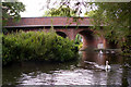
River Colne, London Colney
Looking towards from the east.
Image: © Christine Matthews
Taken: 21 Aug 2009
0.07 miles
9
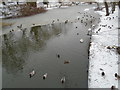
Part-frozen River Colne
Looking from the road bridge leading into the rear of the local industrial estate. Shows the clear area of the river in this area and the wildlife there.
Image: © John Webb
Taken: 2 Mar 2018
0.08 miles
10

Road Bridge at London Colney
Three years ago this area was flooded and much damage was caused to buildings.
Image: © Jack Hill
Taken: 11 Mar 2005
0.08 miles