IMAGES TAKEN NEAR TO
The Drive, ST. ALBANS, AL2 1AJ
Introduction
This page details the photographs taken nearby to The Drive, AL2 1AJ by members of the Geograph project.
The Geograph project started in 2005 with the aim of publishing, organising and preserving representative images for every square kilometre of Great Britain, Ireland and the Isle of Man.

There are currently over 7.5m images from over14,400 individuals and you can help contribute to the project by visiting https://www.geograph.org.uk
Image Map
Images are licensed for reuse under creativecommons.org/licenses/by-sa/2.0
Notes
- Clicking on the map will re-center to the selected point.
- The higher the marker number, the further away the image location is from the centre of the postcode.
Image Listing (6 Images Found)
Images are licensed for reuse under creativecommons.org/licenses/by-sa/2.0
Image
Details
Distance
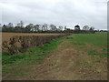
1
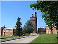
Napsbury Hospital London Colney
The site is now a housing project, The water tower is being left until last in the hopes that a keen
person with half a million pounds will purchase it
Image: © Jack Hill
Taken: 16 Jul 2005
0.06 miles
4
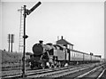
Down local train leaving Napsbury Station
View southward, towards London; ex-Midland London St Pancras - Leicester - Sheffield etc. Main Line. Napsbury station was closed on 14/9/59 - year after this photograph. The 15.40 St Pancras to St Albans is hauled by LMS-type Fairburn4MT 2-6-4T No. 42156.
Image: © Ben Brooksbank
Taken: 30 Aug 1958
0.23 miles