IMAGES TAKEN NEAR TO
Woodstock Road South, ST. ALBANS, AL1 4QH
Introduction
This page details the photographs taken nearby to Woodstock Road South, AL1 4QH by members of the Geograph project.
The Geograph project started in 2005 with the aim of publishing, organising and preserving representative images for every square kilometre of Great Britain, Ireland and the Isle of Man.

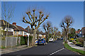
There are currently over 7.5m images from over14,400 individuals and you can help contribute to the project by visiting https://www.geograph.org.uk
Image Map
Images are licensed for reuse under creativecommons.org/licenses/by-sa/2.0
Notes
- Clicking on the map will re-center to the selected point.
- The higher the marker number, the further away the image location is from the centre of the postcode.
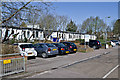
Image Listing (33 Images Found)
Images are licensed for reuse under creativecommons.org/licenses/by-sa/2.0
Image
Details
Distance
1
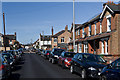
Eaton Road
Late Victorian/early 20th century terraced housing.
Image: © Ian Capper
Taken: 20 Apr 2013
0.02 miles
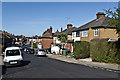
2
Woodstock Road North, Fleetville
At the end of Brampton Road
Image: © David Howard
Taken: 28 May 2015
0.03 miles
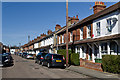
3
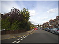
Salisbury Avenue
A stub of Salisbury Avenue where it merges into Eaton Road. Eaton Road consists of late Victorian, early 20th century terraced housing - the exception is nos 17/19, the building on the right of the road in the centre of the photo, with the tall chimney, which was destroyed in an air raid in the Autumn of 1940 and was later rebuilt. Old maps show a sharp edge to development that point, with the semi detached and detached houses of Salisbury Avenue being built in the late 1920s or 1930s.
Image: © Ian Capper
Taken: 20 Apr 2013
0.05 miles
4
Burnham Road
Terraced housing built in 1899.
Image: © Ian Capper
Taken: 20 Apr 2013
0.08 miles
5
Salisbury Avenue
Late 1920s/1930s housing.
Image: © Ian Capper
Taken: 20 Apr 2013
0.08 miles
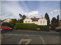
6
Fleetville Community Centre
Well used community centre in Royal Road.
Image: © Ian Capper
Taken: 20 Apr 2013
0.09 miles
8
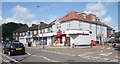
Fleetville Post Office
Fleetville is a district on the east side of St Albans between Marshalswick and The Camp. The post office is on Hatfield Road along with similar small shops and businesses.
Image: © Des Blenkinsopp
Taken: 25 Aug 2024
0.13 miles
9
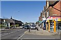
Hatfield Road
Hatfield Road in the Fleetville area of St Albans. On the left is Morrison's Supermarket, built on the site of what was from the 1920s to 1967 the works of Ballito Hosiery and then for a while a factory of Marconi Instruments, eventually part of the electrical and engineering conglomerate GEC.
Image: © Ian Capper
Taken: 20 Apr 2013
0.13 miles
10
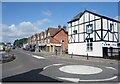
Hatfield Road, St Albans
The main road east out of St Albans to the next town along.
A picture at the mini roundabout by the junction with Sutton Road
Image: © Des Blenkinsopp
Taken: 25 Aug 2024
0.13 miles