IMAGES TAKEN NEAR TO
Jennings Road, ST. ALBANS, AL1 4NZ
Introduction
This page details the photographs taken nearby to Jennings Road, AL1 4NZ by members of the Geograph project.
The Geograph project started in 2005 with the aim of publishing, organising and preserving representative images for every square kilometre of Great Britain, Ireland and the Isle of Man.

There are currently over 7.5m images from over14,400 individuals and you can help contribute to the project by visiting https://www.geograph.org.uk
Image Map
Images are licensed for reuse under creativecommons.org/licenses/by-sa/2.0
Notes
- Clicking on the map will re-center to the selected point.
- The higher the marker number, the further away the image location is from the centre of the postcode.
Image Listing (20 Images Found)
Images are licensed for reuse under creativecommons.org/licenses/by-sa/2.0
Image
Details
Distance
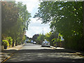
3
Woodstock Road North, Fleetville
At the end of Brampton Road
Image: © David Howard
Taken: 28 May 2015
0.15 miles
4
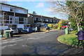
Verulam School
A secondary school for boys, with a mixed sixth form. Founded in 1938, it was for many years the local boys' grammar school, being renamed Verulam School on turning comprehensive in 1975.
Image: © Ian Capper
Taken: 4 Oct 2011
0.16 miles
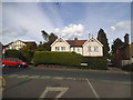
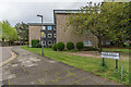
5
St John's Court
An outlying residential development in St Albans.
Image: © Bill Boaden
Taken: 27 Feb 2020
0.17 miles
6
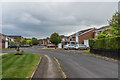
Monks Horton Way
c1960s road off Sandpit Lane.
Image: © Ian Capper
Taken: 1 May 2020
0.17 miles
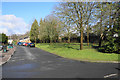
7
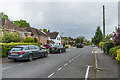
Churchill Road
Road connecting Sandpit Lane and Jennings Road which maps suggest was developed around the 1920s/30s.
Image: © Ian Capper
Taken: 1 May 2020
0.17 miles
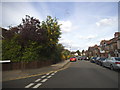
8
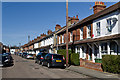
Burnham Road
Terraced housing built in 1899.
Image: © Ian Capper
Taken: 20 Apr 2013
0.19 miles
9
The Dell
c1960s apartment blocks off Sandpit Lane, built on the plot of a large house of the same name dating from around 1903.
Image: © Ian Capper
Taken: 1 May 2020
0.19 miles
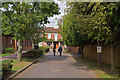
10
Green space at St John's Court
A planned part of the development.
Image: © Bill Boaden
Taken: 27 Feb 2020
0.20 miles