IMAGES TAKEN NEAR TO
Hatfield Road, ST. ALBANS, AL1 4HY
Introduction
This page details the photographs taken nearby to Hatfield Road, AL1 4HY by members of the Geograph project.
The Geograph project started in 2005 with the aim of publishing, organising and preserving representative images for every square kilometre of Great Britain, Ireland and the Isle of Man.

There are currently over 7.5m images from over14,400 individuals and you can help contribute to the project by visiting https://www.geograph.org.uk
Image Map
Images are licensed for reuse under creativecommons.org/licenses/by-sa/2.0
Notes
- Clicking on the map will re-center to the selected point.
- The higher the marker number, the further away the image location is from the centre of the postcode.
Image Listing (182 Images Found)
Images are licensed for reuse under creativecommons.org/licenses/by-sa/2.0
Image
Details
Distance
1
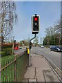
A crossing for the agile-fingered
Hatfield Rd (part of the A1057), St Alban's. On the right is Clarence Park https://www.enjoystalbans.com/listing/clarence-park/ , on the left Station Way. The button to be pressed on this crossing requires some dexterity to reach as there is only a tiny gap between it and the railings behind. In fact there isn't actually a crossing here, only a double set of lights (one for cyclists, one for other vehicles). So why is there a pelican-crossing style button on these lights at all?
Image: © HelenK
Taken: 11 Mar 2023
0.03 miles
2
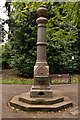
Drinking Fountain, Clarence Park
Drinking fountain made of Aberdeen Granite, donated in 1894 by Lady Emily Blundell-Maple, wife of local furniture magnate Sir John Blundell-Maple who had funded the park. It is locally listed.
Image: © Ian Capper
Taken: 26 Jun 2012
0.04 miles
3
Clarence Park Cafe St Albans
This cafe used to be the public lavatories until
using a toilet went out of fashion.
Image: © Jack Hill
Taken: 5 Jul 2005
0.04 miles
4
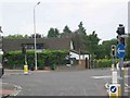
Offices alongside Hatfield Road
Near to St. Albans railway station.
Image: © Steve Fareham
Taken: 13 May 2010
0.04 miles
5
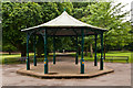
Bandstand, Clarence Park
Clarence Park was laid out in 1894, funded by local furniture magnate Sir John Blundell-Maple. This is the bandstand, a replacement of the lost original using a Heritage Lottery Grant in 1997.
In the background can be seen the drinking fountain in Image
Image: © Ian Capper
Taken: 26 Jun 2012
0.06 miles
6
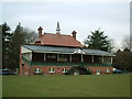
Cricket Pavilion, Clarence Park
Built for the opening of the park in 1894. Originally used by all sports using the park. The football club built their own facilities in the 1920s. Now only used by the hockey and cricket clubs.
http://www.stalbans.gov.uk/leisure/parks/clarence.htm
Image: © Ray Stanton
Taken: 11 Feb 2006
0.09 miles
7
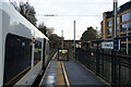
Platform 3, St Albans City Railway Station
The bridge in the distance carries the A1057 Hatfield Road.
Image: © Mark Anderson
Taken: 21 Dec 2022
0.09 miles
8
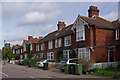
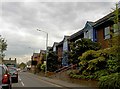
Clarence Road
Two of three similar terraces of cottages dating from 1897. Locally listed.
Image: © Ian Capper
Taken: 4 Oct 2011
0.09 miles
9
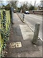
Cable marker, Hatfield Road, St Albans
This warning of an electric cable is in the footway on the east side of the Hatfield Road railway bridge. The view is west.
Image: © Robin Stott
Taken: 6 Apr 2023
0.09 miles
10
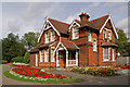
Former Keeper's Lodge, Clarence Park
Late Victorian park-keeper's lodge for Clarence Park, a municipal park laid out in 1894 by the City Surveyor Mr G Ford, following the purchase and then transfer of the land by Sir John Blundell Maple, furniture magnate and resident of nearby Childwickbury (see Image). The land had previously formed part of Earl Spencer's estate. The lodge is locally listed.
Image: © Ian Capper
Taken: 4 Oct 2011
0.10 miles