IMAGES TAKEN NEAR TO
Churchill Road, ST. ALBANS, AL1 4HH
Introduction
This page details the photographs taken nearby to Churchill Road, AL1 4HH by members of the Geograph project.
The Geograph project started in 2005 with the aim of publishing, organising and preserving representative images for every square kilometre of Great Britain, Ireland and the Isle of Man.

There are currently over 7.5m images from over14,400 individuals and you can help contribute to the project by visiting https://www.geograph.org.uk
Image Map
Images are licensed for reuse under creativecommons.org/licenses/by-sa/2.0
Notes
- Clicking on the map will re-center to the selected point.
- The higher the marker number, the further away the image location is from the centre of the postcode.
Image Listing (30 Images Found)
Images are licensed for reuse under creativecommons.org/licenses/by-sa/2.0
Image
Details
Distance
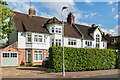
1
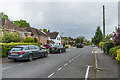
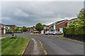
Churchill Road
Road connecting Sandpit Lane and Jennings Road which maps suggest was developed around the 1920s/30s.
Image: © Ian Capper
Taken: 1 May 2020
0.02 miles
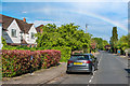
2
Sunderland Avenue
Road connecting Sandpit Lane and Jennings Road which maps suggest was developed around the 1920s/30s.
Image: © Ian Capper
Taken: 1 May 2020
0.06 miles
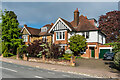
3
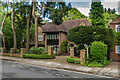
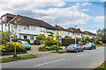
24 Sunderland Avenue
Large house at the north end of Sunderland Avenue, a road connecting Sandpit Lane and Jennings Road which maps suggest was developed around the 1920s/30s.
Image: © Ian Capper
Taken: 1 May 2020
0.06 miles
4
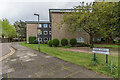
The Dell
c1960s apartment blocks off Sandpit Lane, built on the plot of a large house of the same name dating from around 1903.
Image: © Ian Capper
Taken: 1 May 2020
0.13 miles
5
138 - 140 Clarence Road
Pair of Edwardian semi-detached houses at the north end of Clarence Road. Locally listed.
Image: © Ian Capper
Taken: 1 May 2020
0.14 miles
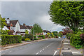
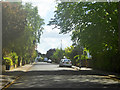
6
Jennings Road
A rainbow over Jennings Road, looking along a section of the road first developed in the 1920s/30s.
Image: © Ian Capper
Taken: 1 May 2020
0.14 miles
7
134 Clarence Road
Edwardian houses towards the northern end of Clarence Road. Locally listed.
Image: © Ian Capper
Taken: 1 May 2020
0.15 miles
9
Monks Horton Way
c1960s road off Sandpit Lane.
Image: © Ian Capper
Taken: 1 May 2020
0.15 miles
10
Charmouth Road
Road developed mainly in the c1930s (first appearing on the 1939 1:2,500 map).
Image: © Ian Capper
Taken: 1 May 2020
0.17 miles