IMAGES TAKEN NEAR TO
Boundary Road, ST. ALBANS, AL1 4EJ
Introduction
This page details the photographs taken nearby to Boundary Road, AL1 4EJ by members of the Geograph project.
The Geograph project started in 2005 with the aim of publishing, organising and preserving representative images for every square kilometre of Great Britain, Ireland and the Isle of Man.

There are currently over 7.5m images from over14,400 individuals and you can help contribute to the project by visiting https://www.geograph.org.uk
Image Map
Images are licensed for reuse under creativecommons.org/licenses/by-sa/2.0
Notes
- Clicking on the map will re-center to the selected point.
- The higher the marker number, the further away the image location is from the centre of the postcode.
Image Listing (127 Images Found)
Images are licensed for reuse under creativecommons.org/licenses/by-sa/2.0
Image
Details
Distance
1
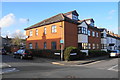
New housing on Boundary Road
This was the site of a Primitive Methodist Church until 1987.
Image: © Bill Boaden
Taken: 29 Feb 2020
0.01 miles
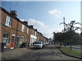
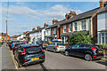
2
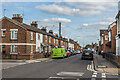
Boundary Road
Housing in the mainly late 19th/early 20th Century development of "Sandridge New Town", an area of land between Sandpit Lane and Sandridge Road, originally outside the boundaries of St Albans and in the parish of Sandridge, prior to the extension of the municipal area in 1879, just south of where Boundary Road was laid out.
Image: © Ian Capper
Taken: 11 Sep 2020
0.02 miles
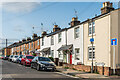
3
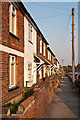
Boundary Road
Late 19th century cottages in an area developed in the late 19th/early 20th centuries as "Sandridge New Town", following the extension in 1879 of the St Albans City boundary to this point, hence the name Boundary Road. Locally listed.
Image: © Ian Capper
Taken: 25 Jul 2012
0.02 miles
4
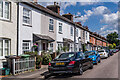
Upper Culver Road
Housing in the mainly late 19th/early 20th Century development of "Sandridge New Town", an area of land between Sandpit Lane and Sandridge Road, originally outside the boundaries of St Albans and in the parish of Sandridge, prior to the extension of the municipal area in 1879, just south of where Boundary Road was laid out.
Image: © Ian Capper
Taken: 5 Jul 2021
0.03 miles
5
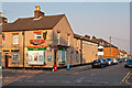
Boundary Road
Corner shop at the junction between Boundary Road and Sandridge Road, in an area developed in the late 19th/early 20th centuries as "Sandridge New Town", following the extension in 1879 of the St Albans City boundary to this point, hence the name Boundary Road.
Image: © Ian Capper
Taken: 25 Jul 2012
0.03 miles
6
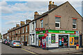
Heath Bakery
Corner shop at the junction of Boundary Road with Sandridge Road at the end of a late Victorian terrace, built as part of "Sandridge New Town". This was an area of land between Sandpit Lane and Sandridge Road, originally outside the boundaries of St Albans and in the parish of Sandridge, prior to the extension of the municipal area in 1879, just south of where Boundary Road was laid out.
Image: © Ian Capper
Taken: 11 Sep 2020
0.04 miles
7
Boundary Road
Housing in the mainly late 19th/early 20th Century development of "Sandridge New Town", an area of land between Sandpit Lane and Sandridge Road, originally outside the boundaries of St Albans and in the parish of Sandridge, prior to the extension of the municipal area in 1879, just south of where Boundary Road was laid out.
Image: © Ian Capper
Taken: 11 Sep 2020
0.04 miles
8
Houses on Sandridge Road, Bernards Heath
Image: © David Howard
Taken: 22 Jul 2014
0.04 miles
9
Culver Road
Housing in the mainly late 19th/early 20th Century development of "Sandridge New Town", an area of land between Sandpit Lane and Sandridge Road, originally outside the boundaries of St Albans and in the parish of Sandridge, prior to the extension of the municipal area in 1879, just south of where Boundary Road was laid out.
Image: © Ian Capper
Taken: 11 Sep 2020
0.05 miles
10
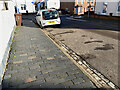
Paving, Heath Road, St Albans
Heath Road offers an example of the appealing blue brick paving seen in St Albans, here moderately well-worn. The channel by the kerb appears also to be of blue brick, washed to a lighter colour. Towards the car it changes, perhaps to the granodiorite setts identified on page 23 of the Hertfordshire Strategic Stone Study https://www2.bgs.ac.uk/mineralsuk/download/EHCountyAtlases/Hertfordshire_Building_Stone_Atlas.pdf See also Image Fellow-contributor Ian Capper has documented this area of St Albans, Sandridge New Town, and its history in an excellent series of photographs: for example Image, where the blue brick paving makes an appearance.
Image: © Robin Stott
Taken: 21 Jan 2023
0.05 miles