IMAGES TAKEN NEAR TO
Boundary Road, ST. ALBANS, AL1 4DH
Introduction
This page details the photographs taken nearby to Boundary Road, AL1 4DH by members of the Geograph project.
The Geograph project started in 2005 with the aim of publishing, organising and preserving representative images for every square kilometre of Great Britain, Ireland and the Isle of Man.

There are currently over 7.5m images from over14,400 individuals and you can help contribute to the project by visiting https://www.geograph.org.uk
Image Map
Images are licensed for reuse under creativecommons.org/licenses/by-sa/2.0
Notes
- Clicking on the map will re-center to the selected point.
- The higher the marker number, the further away the image location is from the centre of the postcode.
Image Listing (137 Images Found)
Images are licensed for reuse under creativecommons.org/licenses/by-sa/2.0
Image
Details
Distance
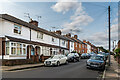
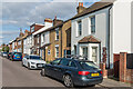
1
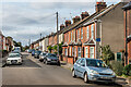
Boundary Road
Housing in the mainly late 19th/early 20th Century development of "Sandridge New Town", an area of land between Sandpit Lane and Sandridge Road, originally outside the boundaries of St Albans and in the parish of Sandridge, prior to the extension of the municipal area in 1879, just south of where Boundary Road was laid out.
Image: © Ian Capper
Taken: 11 Sep 2020
0.01 miles
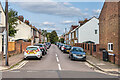
2
Boundary Road
Housing in the mainly late 19th/early 20th Century development of "Sandridge New Town", an area of land between Sandpit Lane and Sandridge Road, originally outside the boundaries of St Albans and in the parish of Sandridge, prior to the extension of the municipal area in 1879, just south of where Boundary Road was laid out.
Image: © Ian Capper
Taken: 11 Sep 2020
0.01 miles
3
Boundary Road
Housing in the mainly late 19th/early 20th Century development of "Sandridge New Town", an area of land between Sandpit Lane and Sandridge Road, originally outside the boundaries of St Albans and in the parish of Sandridge, prior to the extension of the municipal area in 1879, just south of where Boundary Road was laid out.
Image: © Ian Capper
Taken: 11 Sep 2020
0.01 miles
4
Boundary Road
Housing in the mainly late 19th/early 20th Century development of "Sandridge New Town", an area of land between Sandpit Lane and Sandridge Road, originally outside the boundaries of St Albans and in the parish of Sandridge, prior to the extension of the municipal area in 1879, just south of where Boundary Road was laid out.
Image: © Ian Capper
Taken: 11 Sep 2020
0.01 miles
5
Boundary Road
Housing in the mainly late 19th/early 20th Century development of "Sandridge New Town", an area of land between Sandpit Lane and Sandridge Road, originally outside the boundaries of St Albans and in the parish of Sandridge, prior to the extension of the municipal area in 1879, just south of where Boundary Road was laid out.
Image: © Ian Capper
Taken: 11 Sep 2020
0.01 miles
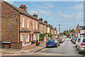
6
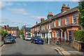
Walton Street
Housing in the mainly late 19th/early 20th Century development of "Sandridge New Town", an area of land between Sandpit Lane and Sandridge Road, originally outside the boundaries of St Albans and in the parish of Sandridge, prior to the extension of the municipal area in 1879, just south of where Boundary Road (in the background) was laid out. Maps suggest that Walton Street was one of the later roads to be developed, with the houses on this side being on what was previously part of the land surrounding St Saviour's Church.
Image: © Ian Capper
Taken: 11 Sep 2020
0.02 miles
7
Walton Street
Housing in the mainly late 19th/early 20th Century development of "Sandridge New Town", an area of land between Sandpit Lane and Sandridge Road, originally outside the boundaries of St Albans and in the parish of Sandridge, prior to the extension of the municipal area in 1879, just south of where Boundary Road (in the foreground) was laid out. Maps suggest that Walton Street was one of the later roads to be developed, with the houses on this side being on what was previously part of the land surrounding St Saviour's Church, the top of whose spire can be seen in the background.
Image: © Ian Capper
Taken: 11 Sep 2020
0.02 miles
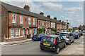
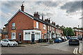
8
Warwick Road
Housing in the mainly late 19th/early 20th Century development of "Sandridge New Town", an area of land between Sandpit Lane and Sandridge Road, originally outside the boundaries of St Albans and in the parish of Sandridge, prior to the extension of the municipal area in 1879, just south of where Boundary Road was laid out.
Warwick Road was one of the later roads to be developed, and even then only the western side (seen here). The eastern side was not developed until the 1980s onwards (see Image).
Image: © Ian Capper
Taken: 5 Jul 2021
0.03 miles
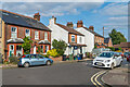
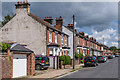
9
Upper Heath Road
Housing in the mainly late 19th/early 20th Century development of "Sandridge New Town", an area of land between Sandpit Lane and Sandridge Road, originally outside the boundaries of St Albans and in the parish of Sandridge, prior to the extension of the municipal area in 1879, just south of where Boundary Road was laid out. Upper Heath Road is the extension of Heath Road north of Boundary Road.
Image: © Ian Capper
Taken: 11 Sep 2020
0.03 miles
10
Upper Heath Road
Housing in the mainly late 19th/early 20th Century development of "Sandridge New Town", an area of land between Sandpit Lane and Sandridge Road, originally outside the boundaries of St Albans and in the parish of Sandridge, prior to the extension of the municipal area in 1879, just south of where Boundary Road was laid out. Upper Heath Road is the extension of Heath Road north of Boundary Road (in the foreground).
Image: © Ian Capper
Taken: 11 Sep 2020
0.03 miles