IMAGES TAKEN NEAR TO
Sandridge Road, ST. ALBANS, AL1 4AR
Introduction
This page details the photographs taken nearby to Sandridge Road, AL1 4AR by members of the Geograph project.
The Geograph project started in 2005 with the aim of publishing, organising and preserving representative images for every square kilometre of Great Britain, Ireland and the Isle of Man.

There are currently over 7.5m images from over14,400 individuals and you can help contribute to the project by visiting https://www.geograph.org.uk
Image Map
Images are licensed for reuse under creativecommons.org/licenses/by-sa/2.0
Notes
- Clicking on the map will re-center to the selected point.
- The higher the marker number, the further away the image location is from the centre of the postcode.
Image Listing (139 Images Found)
Images are licensed for reuse under creativecommons.org/licenses/by-sa/2.0
Image
Details
Distance
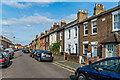
1
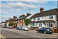
Sandridge Road
Late Victorian/early 20th Century housing towards the southern end of Sandridge Road. The second group has a name plaque with the inscription "Geneva Cottages 1884".
Image: © Ian Capper
Taken: 11 Sep 2020
0.03 miles
2
Culver Road
Housing in the mainly late 19th/early 20th Century development of "Sandridge New Town", an area of land between Sandpit Lane and Sandridge Road, originally outside the boundaries of St Albans and in the parish of Sandridge, prior to the extension of the municipal area in 1879, just south of where Boundary Road was laid out.
Image: © Ian Capper
Taken: 5 Jul 2021
0.03 miles
3
Culver Road
Housing in the mainly late 19th/early 20th Century development of "Sandridge New Town", an area of land between Sandpit Lane and Sandridge Road, originally outside the boundaries of St Albans and in the parish of Sandridge, prior to the extension of the municipal area in 1879, just south of where Boundary Road was laid out.
Image: © Ian Capper
Taken: 11 Sep 2020
0.04 miles
4
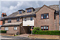
Culver Lodge
Late 1980s development of 7 flats in Culver Road, built on the site of a former mission room, serving the mainly late 19th/early 20th Century development of "Sandridge New Town". This was an area of land between Sandpit Lane and Sandridge Road, originally outside the boundaries of St Albans and in the parish of Sandridge, prior to the extension of the municipal area in 1879, just south of where Boundary Road was laid out. The original building later served as St Saviour's Church Hall before being used for various commercial purposes.
Image: © Ian Capper
Taken: 5 Jul 2021
0.04 miles
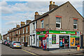
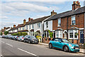
5
Boundary Road
Corner shop at the junction between Boundary Road and Sandridge Road, in an area developed in the late 19th/early 20th centuries as "Sandridge New Town", following the extension in 1879 of the St Albans City boundary to this point, hence the name Boundary Road.
Image: © Ian Capper
Taken: 25 Jul 2012
0.05 miles
6
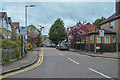
St Albans : Spencer Gate
Looking along Spencer Gate from Sandridge Road.
Image: © Lewis Clarke
Taken: 27 Apr 2019
0.05 miles
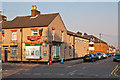
7
Heath Bakery
Corner shop at the junction of Boundary Road with Sandridge Road at the end of a late Victorian terrace, built as part of "Sandridge New Town". This was an area of land between Sandpit Lane and Sandridge Road, originally outside the boundaries of St Albans and in the parish of Sandridge, prior to the extension of the municipal area in 1879, just south of where Boundary Road was laid out.
Image: © Ian Capper
Taken: 11 Sep 2020
0.05 miles
8
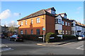
New housing on Boundary Road
This was the site of a Primitive Methodist Church until 1987.
Image: © Bill Boaden
Taken: 29 Feb 2020
0.06 miles
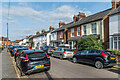
9
Culver Road
Housing in the mainly late 19th/early 20th Century development of "Sandridge New Town", an area of land between Sandpit Lane and Sandridge Road, originally outside the boundaries of St Albans and in the parish of Sandridge, prior to the extension of the municipal area in 1879, just south of where Boundary Road was laid out. The plaque on the right is inscribed "Weldon Cottages 1882", with one further along inscribed "Culver Cottages".
Image: © Ian Capper
Taken: 11 Sep 2020
0.06 miles
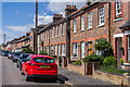
10
Sandridge Road
Late Victorian/early 20th Century terraced housing towards the southern end of Sandridge Road.
Image: © Ian Capper
Taken: 11 Sep 2020
0.06 miles