IMAGES TAKEN NEAR TO
Marlborough Gate, ST. ALBANS, AL1 3TX
Introduction
This page details the photographs taken nearby to Marlborough Gate, AL1 3TX by members of the Geograph project.
The Geograph project started in 2005 with the aim of publishing, organising and preserving representative images for every square kilometre of Great Britain, Ireland and the Isle of Man.

There are currently over 7.5m images from over14,400 individuals and you can help contribute to the project by visiting https://www.geograph.org.uk
Image Map
Images are licensed for reuse under creativecommons.org/licenses/by-sa/2.0
Notes
- Clicking on the map will re-center to the selected point.
- The higher the marker number, the further away the image location is from the centre of the postcode.
Image Listing (292 Images Found)
Images are licensed for reuse under creativecommons.org/licenses/by-sa/2.0
Image
Details
Distance
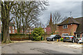
1
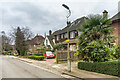
Marlborough Gate
Cul-de-sac off Upper Latimore Road, developed in 1923 on the former land of Marlborough House (see Image), following the sale of the house to Loreto College that year.
Image: © Ian Capper
Taken: 21 Feb 2020
0.01 miles
2
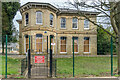
St Josephs
Large Victorian house built around 1860. Its biggest claim to fame is that from 1906 to 1923 it was home to Samuel Ryder, seed merchant and philanthropist and sponsor of the initial Ryder Cup golf competition. In 1923 it was bought by Loreto College, a Roman Catholic girls' school founded the previous year in a next door house, The Elms, with Marlborough House being renamed St Josephs.
Image: © Ian Capper
Taken: 21 Feb 2020
0.03 miles
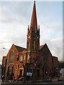
3
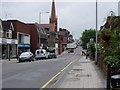
Victoria Street St Albans
looking towards Trinity United Reformed Church
Image: © HENRY CLARK
Taken: 30 May 2008
0.04 miles
4
Marlborough Gate
Cul-de-sac off Upper Latimore Road, developed in 1923 on the former land of Marlborough House (see Image), following the sale of the house to Loreto College that year.
Image: © Ian Capper
Taken: 21 Feb 2020
0.04 miles
5
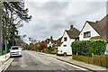
Marlborough Gate
Cul-de-sac off Upper Latimore Road, developed in 1923 on the former land of Marlborough House (see Image), following the sale of the house to Loreto College that year. This is the turning circle at the end, with a footpath off to the right leading to Victoria Street. In the background is the spire of Trinity Church.
Image: © Ian Capper
Taken: 21 Feb 2020
0.04 miles
6
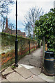
Footpath to Victoria Street
Footpath connecting the end of Marlborough Gate with Victoria Street. See Image for a wider photo. In the left background is Trinity Church.
Image: © Ian Capper
Taken: 21 Feb 2020
0.04 miles
7
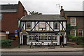
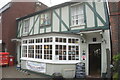
The Robin Hood
A Victorian pub hidden between an Iceland supermarket and some terraced cottages.
Image: © Ian Capper
Taken: 4 Oct 2011
0.05 miles
9
The Robin Hood public house
On Victoria Street, St Albans.
Image: © Ian S
Taken: 18 Jun 2022
0.05 miles
10
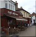
Cafe Alfresco, Victoria Street
Next door is the Victoria pub
Image: © Robert Eva
Taken: 6 May 2017
0.06 miles