IMAGES TAKEN NEAR TO
St. Peters Road, ST. ALBANS, AL1 3SA
Introduction
This page details the photographs taken nearby to St. Peters Road, AL1 3SA by members of the Geograph project.
The Geograph project started in 2005 with the aim of publishing, organising and preserving representative images for every square kilometre of Great Britain, Ireland and the Isle of Man.

There are currently over 7.5m images from over14,400 individuals and you can help contribute to the project by visiting https://www.geograph.org.uk
Image Map
Images are licensed for reuse under creativecommons.org/licenses/by-sa/2.0
Notes
- Clicking on the map will re-center to the selected point.
- The higher the marker number, the further away the image location is from the centre of the postcode.
Image Listing (258 Images Found)
Images are licensed for reuse under creativecommons.org/licenses/by-sa/2.0
Image
Details
Distance
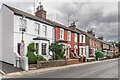
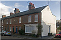
1
St Peter's Road
Largely semi-detached villas built in the 1880s. Locally listed.
Image: © Ian Capper
Taken: 2 Oct 2011
0.01 miles
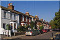
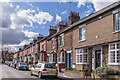
2
St Peter's Road
Late 19th Century housing in St Peter's Road. The plaque on the building to right of centre reads "Park Villas".
Image: © Ian Capper
Taken: 5 Jul 2021
0.01 miles
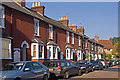
3
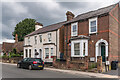
9 - 13 St Peter's Road
Late 19th Century housing in St Peter's Road. Beyond them on the left are St Peter's Almshouses - see Image
Image: © Ian Capper
Taken: 5 Jul 2021
0.03 miles
4
Clifton Street
1880s terraced housing, with the addition of a shopfront in no 17. Locally listed.
Image: © Ian Capper
Taken: 3 Dec 2011
0.03 miles
5
Clifton Street
Terraced cottages built in the 1880s. Locally listed.
Image: © Ian Capper
Taken: 14 Mar 2022
0.04 miles
6
Clifton Street
Terraced cottages built in the 1880s. Locally listed.
Image: © Ian Capper
Taken: 2 Oct 2011
0.04 miles
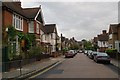
7
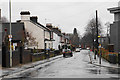
St Peter's Road in the rain
A residential road in easy walking distance from the city centre.
Image: © Bill Boaden
Taken: 28 Feb 2020
0.04 miles
8
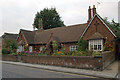
St Peter's Almshouses
A set of four almshouses built in around 1870 and administered by the Dudding & Bennett United Almshouse Charities, betraying their origin as two separate pairs of almshouses linked together - the Dudding Almshouses, built by the Reverend Horatio Nelson Dudding, a former vicar of St. Peter's Church, and the Bennett Almshouses. They are locally listed.
Image: © Ian Capper
Taken: 22 Sep 2011
0.05 miles
9
Hall Place Gardens
Part of the estate planned by local architect, Harry Steer, in 1907 on the site of Townsend Farm and Hall Place, the latter an important mid 15th century building in which Henry VI was held after the First Battle of St Albans in 1455 which had been demolished in 1907. Most of the buildings are locally listed.
Image: © Ian Capper
Taken: 22 Sep 2011
0.05 miles