IMAGES TAKEN NEAR TO
St. Peters Road, ST. ALBANS, AL1 3RU
Introduction
This page details the photographs taken nearby to St. Peters Road, AL1 3RU by members of the Geograph project.
The Geograph project started in 2005 with the aim of publishing, organising and preserving representative images for every square kilometre of Great Britain, Ireland and the Isle of Man.

There are currently over 7.5m images from over14,400 individuals and you can help contribute to the project by visiting https://www.geograph.org.uk
Image Map
Images are licensed for reuse under creativecommons.org/licenses/by-sa/2.0
Notes
- Clicking on the map will re-center to the selected point.
- The higher the marker number, the further away the image location is from the centre of the postcode.
Image Listing (304 Images Found)
Images are licensed for reuse under creativecommons.org/licenses/by-sa/2.0
Image
Details
Distance
1
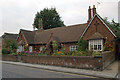
St Peter's Almshouses
A set of four almshouses built in around 1870 and administered by the Dudding & Bennett United Almshouse Charities, betraying their origin as two separate pairs of almshouses linked together - the Dudding Almshouses, built by the Reverend Horatio Nelson Dudding, a former vicar of St. Peter's Church, and the Bennett Almshouses. They are locally listed.
Image: © Ian Capper
Taken: 22 Sep 2011
0.00 miles
2
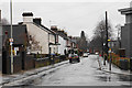
St Peter's Road in the rain
A residential road in easy walking distance from the city centre.
Image: © Bill Boaden
Taken: 28 Feb 2020
0.00 miles
3
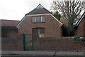
Electricity sub-station, St Peter's Road
Built in 1931, it is locally listed.
Image: © Ian Capper
Taken: 3 Dec 2011
0.01 miles
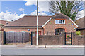
4
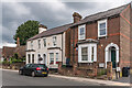
9 - 13 St Peter's Road
Late 19th Century housing in St Peter's Road. Beyond them on the left are St Peter's Almshouses - see Image
Image: © Ian Capper
Taken: 5 Jul 2021
0.01 miles
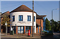
5
The Old Substation
Former electricity substation, built in 1931. It was converted into housing in 2013.
Image: © Ian Capper
Taken: 14 Mar 2022
0.01 miles
6
Oaklands College
A further education college with various sites around Hertfordshire, including two in St Albans. This is the City Campus on Hatfield Road.
Image: © Ian Capper
Taken: 2 Oct 2011
0.02 miles
7
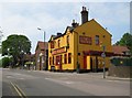
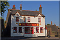
St Albans: The Peacock
A pub in Hatfield Road, this was once The Peacock, then O'Neill's, then Ryans, then O'Neill's, and now back to The Peacock.
Image: © Nigel Cox
Taken: 25 May 2010
0.03 miles
8
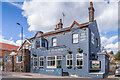
The Peacock
A locally listed pub on Hatfield Road. In a couple of years between 2007 and 2009 it went through various name changes: O'Neills, Ryans then back to O'Neills. It has now reverted to its original name, The Peacock. A 1634 map shows an Inn called The Peacock on the site, although the current building is clearly more recent, dating from the late 19th/early 20th century. Compare Image for how it looked in 2011.
Image: © Ian Capper
Taken: 14 Mar 2022
0.03 miles
9
The Peacock
A locally listed pub on Hatfield Road. In a couple of years between 2007 and 2009 it went through various name changes: O'Neills, Ryans then back to O'Neills. It has now reverted to its original name, The Peacock. A 1634 map shows an Inn called The Peacock on the site, although the current building is clearly more recent, dating from the late 19th/early 20th century.
Image: © Ian Capper
Taken: 2 Oct 2011
0.03 miles
10
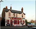
The Peacock, Hatfield Road
Public house on Hatfield Road.
There is a bench mark http://www.geograph.org.uk/photo/4745571 on the bottom left corner.
Image: © Alan Murray-Rust
Taken: 2 Nov 2015
0.03 miles