IMAGES TAKEN NEAR TO
Hillside Road, ST. ALBANS, AL1 3QU
Introduction
This page details the photographs taken nearby to Hillside Road, AL1 3QU by members of the Geograph project.
The Geograph project started in 2005 with the aim of publishing, organising and preserving representative images for every square kilometre of Great Britain, Ireland and the Isle of Man.

There are currently over 7.5m images from over14,400 individuals and you can help contribute to the project by visiting https://www.geograph.org.uk
Image Map
Images are licensed for reuse under creativecommons.org/licenses/by-sa/2.0
Notes
- Clicking on the map will re-center to the selected point.
- The higher the marker number, the further away the image location is from the centre of the postcode.
Image Listing (246 Images Found)
Images are licensed for reuse under creativecommons.org/licenses/by-sa/2.0
Image
Details
Distance
1
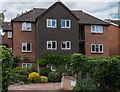
Rowlatt Court
1980s development in Hillside Road, built on what maps suggest was a previously undeveloped plot, despite the road having been laid out in the late 19th Century and largely developed by the early 20th Century.
Image: © Ian Capper
Taken: 24 Jul 2020
0.01 miles
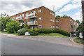
2
Hillside Court
c1960s development in Hillside Road, built on what maps suggest was a previously undeveloped plot, despite the road having been laid out in the late 19th Century and largely developed by the early 20th Century.
Image: © Ian Capper
Taken: 24 Jul 2020
0.02 miles
3
Murton Court
c1970s development in Hillside Road, built on the plot of a former nursing home.
Image: © Ian Capper
Taken: 24 Jul 2020
0.03 miles
4
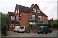
Old Lyndale School
c1990s conversion of a late 19th Century house in Hillside Road into 8 flats with a further 6 flat in a development behind. From 1929 to 1993 the building housed a small private school.
Image: © Ian Capper
Taken: 24 Jul 2020
0.03 miles
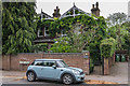
5
Old Lyndale School
A large Victorian house which housed a private school from 1929 to 1993. It has now been converted to flats. Locally listed.
Image: © Ian Capper
Taken: 22 Sep 2011
0.04 miles
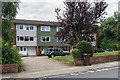
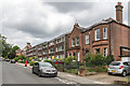
6
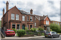
4 and 6 Hillside Road
Late 19th Century houses in Hillside Road.
Image: © Ian Capper
Taken: 24 Jul 2020
0.04 miles
7
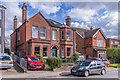
4 & 6 Hillside Road
Pair of c.1880s houses in Hillside Road.
Image: © Ian Capper
Taken: 14 Mar 2022
0.04 miles
8
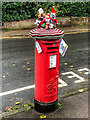
"St Albans Postboxes"
Postbox in Hillside Road.
The postbox is one of 50 "yarnbombed" boxes in St Albans and area, part of an initiative known as "St Albans postboxes" started at Christmas 2018. For Christmas 2020, each box topper has a seasonal theme with the year's specific objective being to raise money for two charities, Open Doors and the St Albans and District Foodbank.
Image: © Ian Capper
Taken: 18 Dec 2020
0.04 miles
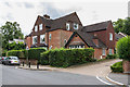
9
1 Hillside Road
Late 19th Century house in Hillside Road by its junction with St Peter's Road.
Image: © Ian Capper
Taken: 24 Jul 2020
0.05 miles
10
6 Hillside Road and Hillside Gate
6 Hillside Road dates from the late 19th Century. Hillside Gate was a 1960s development on the plots of two further such houses.
Image: © Ian Capper
Taken: 24 Jul 2020
0.05 miles