IMAGES TAKEN NEAR TO
Lemsford Road, ST. ALBANS, AL1 3PF
Introduction
This page details the photographs taken nearby to Lemsford Road, AL1 3PF by members of the Geograph project.
The Geograph project started in 2005 with the aim of publishing, organising and preserving representative images for every square kilometre of Great Britain, Ireland and the Isle of Man.

There are currently over 7.5m images from over14,400 individuals and you can help contribute to the project by visiting https://www.geograph.org.uk
Image Map
Images are licensed for reuse under creativecommons.org/licenses/by-sa/2.0
Notes
- Clicking on the map will re-center to the selected point.
- The higher the marker number, the further away the image location is from the centre of the postcode.
Image Listing (154 Images Found)
Images are licensed for reuse under creativecommons.org/licenses/by-sa/2.0
Image
Details
Distance
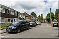
1
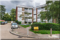
Thirlstane
1960s development of 7 blocks of flats off Lemsford Road.
Image: © Ian Capper
Taken: 5 Jul 2021
0.01 miles
2
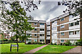
Thirlstane
1960s development of 7 blocks of flats off Lemsford Road.
Image: © Ian Capper
Taken: 5 Jul 2021
0.04 miles
3
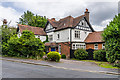
50 Lemsford Road
Turn of the 19th/20th Centuries house on Lemsford Road.
Image: © Ian Capper
Taken: 25 Jul 2020
0.05 miles
4
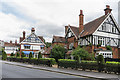
Ardmore House Hotel
Hotel on Lemsford Road, developed out of two turn of the 19th/20th Centuries houses.
Image: © Ian Capper
Taken: 25 Jul 2020
0.07 miles
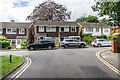
5
Althorp Road
Houses at the end of Althorp Road, built in the 1960s together with Hillside Court in Hillside Road on the site of two large houses in the latter road. The three houses in the background were part of a separate development in the early 1990s named Spencer Mews. Althorp Road itself dates originally from the early 20th Century with two large houses in large plots on either side of the road.
Image: © Ian Capper
Taken: 24 Jul 2020
0.07 miles
6
Althorp Road
Houses at the end of Althorp Road, built in the 1960s together with Hillside Court in Hillside Road on the site of two large houses in the latter road. Althorp Road itself dates originally from the early 20th Century with two large houses in large plots on either side of the road.
Image: © Ian Capper
Taken: 24 Jul 2020
0.07 miles

8
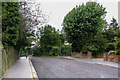
York Road
Cul-de-sac bordering Clarence Park, developed over the first two or so decades of the 20th Century. At its end, as seen here, is a footbridge over the railway linking it to Lemsford Road. A footbridge here is marked on the 1878-9 and 1898 1:2,500 maps along with a footpath along the later route of the road.
Image: © Ian Capper
Taken: 25 Jul 2020
0.09 miles
9
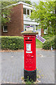
"St Albans Postboxes"
Postbox at the corner of Manor Road and Lemsford Road, with one of the blocks of flats in Thirsltane behind.
The postbox is one of 12 "yarnbombed" boxes in St Albans, part of an initiative known as "St Albans postboxes" started at Christmas 2018. For summer 2020, each box topper has a floral theme with the year's specific objective being to raise money for two charities, Open Doors and the St Albans and District Foodbank. The design of this one was by Lucy Dronfield and sponsored by two local businesses, Sleep Time Baby and Centred Mums.
Image: © Ian Capper
Taken: 25 Jul 2020
0.09 miles
10
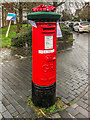
"St Albans Postboxes"
Postbox at the corner of Manor Road and Lemsford Road.
The postbox is one of 50 "yarnbombed" boxes in St Albans and area, part of an initiative known as "St Albans postboxes" started at Christmas 2018. For Christmas 2020, each box topper has a seasonal theme with the year's specific objective being to raise money for two charities, Open Doors and the St Albans and District Foodbank.
Image: © Ian Capper
Taken: 18 Dec 2020
0.09 miles