IMAGES TAKEN NEAR TO
Lemsford Road, ST. ALBANS, AL1 3PB
Introduction
This page details the photographs taken nearby to Lemsford Road, AL1 3PB by members of the Geograph project.
The Geograph project started in 2005 with the aim of publishing, organising and preserving representative images for every square kilometre of Great Britain, Ireland and the Isle of Man.

There are currently over 7.5m images from over14,400 individuals and you can help contribute to the project by visiting https://www.geograph.org.uk
Image Map
Images are licensed for reuse under creativecommons.org/licenses/by-sa/2.0
Notes
- Clicking on the map will re-center to the selected point.
- The higher the marker number, the further away the image location is from the centre of the postcode.
Image Listing (138 Images Found)
Images are licensed for reuse under creativecommons.org/licenses/by-sa/2.0
Image
Details
Distance
1
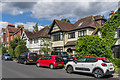
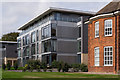
Lemsford Road
A mix of late Victorian (in the left background) and c1930s housing in Lemsford Road.
Image: © Ian Capper
Taken: 11 Jul 2020
0.02 miles
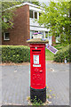
2
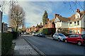
North on Lemsford Road, St Albans
Houses from the early 20th century look across to sleek blocks of flats from the later 20th century.
Image: © Robin Stott
Taken: 30 Jan 2023
0.02 miles
3
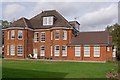
Tunbridge Court, Newsom Place
Redevelopment of one of the existing buildings on the Oaklands College site, in contrast to the modern new build of studios and apartments elsewhere on the site (see Image for example).
Image: © Ian Capper
Taken: 4 Oct 2011
0.03 miles
4
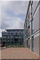
Newsom Place
A development of studios and apartments on part of the Oaklands College site off Lemsford Road, completed in 2011. On the right is Winchester Court, with Queens Court in the background.
Image: © Ian Capper
Taken: 4 Oct 2011
0.04 miles
5
Oriel Court, Newsom Place
A block in a development of studios and apartments on part of the Oaklands College site off Manor Road, completed in 2011. To its right is part of Tunbridge Court, a redevelopment of one of the original buildings on the site (see Image).
Image: © Ian Capper
Taken: 4 Oct 2011
0.04 miles
6
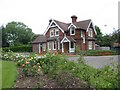
The Lodge Clarence Park St Albans
A tied cottage provided for the Parks Superintendent. His office is the small room to the left
Image: © Jack Hill
Taken: 5 Jul 2005
0.04 miles
7
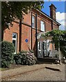
Blue plaque, St Albans
The plaque records that from 1950 to 1959 this was the home of Professor Stephen Hawking (1942-2018), "Theoretical physicist, cosmologist and author". This private property was photographed from the street.
Image: © Robin Stott
Taken: 19 Aug 2023
0.04 miles
8
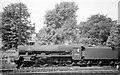
Express viewed from Clarence Park
Jubilee 4-6-0 45594 Bhopal passes Clarence Park just to the north of St Albans City Station with a train for St Pancras
Image: © John Firth
Taken: Unknown
0.04 miles
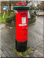
9
"St Albans Postboxes"
Postbox at the corner of Manor Road and Lemsford Road, with one of the blocks of flats in Thirsltane behind.
The postbox is one of 12 "yarnbombed" boxes in St Albans, part of an initiative known as "St Albans postboxes" started at Christmas 2018. For summer 2020, each box topper has a floral theme with the year's specific objective being to raise money for two charities, Open Doors and the St Albans and District Foodbank. The design of this one was by Lucy Dronfield and sponsored by two local businesses, Sleep Time Baby and Centred Mums.
Image: © Ian Capper
Taken: 25 Jul 2020
0.04 miles
10
"St Albans Postboxes"
Postbox at the corner of Manor Road and Lemsford Road.
The postbox is one of 50 "yarnbombed" boxes in St Albans and area, part of an initiative known as "St Albans postboxes" started at Christmas 2018. For Christmas 2020, each box topper has a seasonal theme with the year's specific objective being to raise money for two charities, Open Doors and the St Albans and District Foodbank.
Image: © Ian Capper
Taken: 18 Dec 2020
0.04 miles