IMAGES TAKEN NEAR TO
Upper Lattimore Road, ST. ALBANS, AL1 3NU
Introduction
This page details the photographs taken nearby to Upper Lattimore Road, AL1 3NU by members of the Geograph project.
The Geograph project started in 2005 with the aim of publishing, organising and preserving representative images for every square kilometre of Great Britain, Ireland and the Isle of Man.

There are currently over 7.5m images from over14,400 individuals and you can help contribute to the project by visiting https://www.geograph.org.uk
Image Map
Images are licensed for reuse under creativecommons.org/licenses/by-sa/2.0
Notes
- Clicking on the map will re-center to the selected point.
- The higher the marker number, the further away the image location is from the centre of the postcode.
Image Listing (319 Images Found)
Images are licensed for reuse under creativecommons.org/licenses/by-sa/2.0
Image
Details
Distance
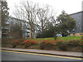
2
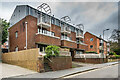
Chalfont Place
1980s development of 15 apartments on the site of 33 Upper Lattimore Road, itself only built in the c.1960s according to maps. Beyond is Avondale Court, built on the site of what maps suggest was a Victorian house, later (until the 1960s) a nursing home, Brooklands (a name retained in a large neighbouring development in Hatfield Road on the site of what had been local council offices), and then (in the 1970s) a car park (presumably for the council offices).
Image: © Ian Capper
Taken: 21 Feb 2020
0.02 miles
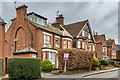
3
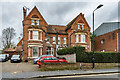
27 - 29 Upper Lattimore Road
Pair of large late Victorian semi-detached houses in Upper Lattimore Road.
Image: © Ian Capper
Taken: 21 Feb 2020
0.03 miles
4
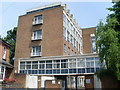
St Albans Telephone Exchange
Dating from 1958, it is situated at the end of Liverpool Road and replaced the former Manual TE. Its postcode is AL1 3UL.
Image: © David Hillas
Taken: 23 May 2009
0.05 miles
5
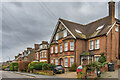
23 - 25 Upper Lattimore Road
Pair of c. early 20th Century semi-detached houses in Upper Lattimore Road. Maps suggest that it was built slightly later than its neighbours beyond, which are late Victorian.
Image: © Ian Capper
Taken: 21 Feb 2020
0.05 miles
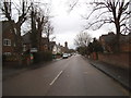
6
Upper Lattimore Road
Houses in Upper Lattimore Road. Maps suggest that the outer two buildings are late Victorian, sandwiching a slightly later one in the middle, perhaps early 20th Century.
Image: © Ian Capper
Taken: 21 Feb 2020
0.05 miles
7
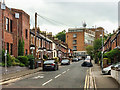
Liverpool Road
A cul de sac of 1880s terraced housing, with the 1958 telephone exchange in the background.
Image: © Ian Capper
Taken: 17 May 2019
0.06 miles
8
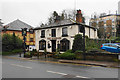
The Mermaid
A pub on Hatfield Road on the edge of the city centre.
Image: © Bill Boaden
Taken: 28 Feb 2020
0.06 miles
9
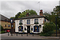
The Mermaid
Locally listed pub on Hatfield Road.
Image: © Ian Capper
Taken: 4 Oct 2011
0.06 miles