IMAGES TAKEN NEAR TO
Newsom Place, Hatfield Road, ST. ALBANS, AL1 3GQ
Introduction
This page details the photographs taken nearby to Newsom Place, Hatfield Road, AL1 3GQ by members of the Geograph project.
The Geograph project started in 2005 with the aim of publishing, organising and preserving representative images for every square kilometre of Great Britain, Ireland and the Isle of Man.

There are currently over 7.5m images from over14,400 individuals and you can help contribute to the project by visiting https://www.geograph.org.uk
Image Map
Images are licensed for reuse under creativecommons.org/licenses/by-sa/2.0
Notes
- Clicking on the map will re-center to the selected point.
- The higher the marker number, the further away the image location is from the centre of the postcode.
Image Listing (164 Images Found)
Images are licensed for reuse under creativecommons.org/licenses/by-sa/2.0
Image
Details
Distance
1
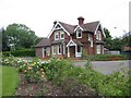
The Lodge Clarence Park St Albans
A tied cottage provided for the Parks Superintendent. His office is the small room to the left
Image: © Jack Hill
Taken: 5 Jul 2005
0.02 miles
2
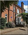
Blue plaque, St Albans
The plaque records that from 1950 to 1959 this was the home of Professor Stephen Hawking (1942-2018), "Theoretical physicist, cosmologist and author". This private property was photographed from the street.
Image: © Robin Stott
Taken: 19 Aug 2023
0.02 miles
3
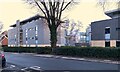
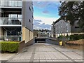
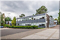
Flats off Newsom Place, St Albans
This view is from Manor Road. Old maps show that by the turn of the 19th and 20th centuries this area (bounded by Lemsford Road, Manor Road, St Peter's Road and Hatfield Road) was filling up with large detached houses with large gardens. Ian Capper refers to it in 2021 as the Oaklands College site Image His photo illustrates partial redevelopment that was completed in 2011. Construction works observed in 2023 suggest that even that is being replaced by blocks in the style shown above. Aerial photos show about 20 such blocks across the whole site.
Image: © Robin Stott
Taken: 7 Mar 2023
0.02 miles
4
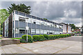
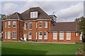
Newsom Place
A development of studios and apartments on part of the Oaklands College site off Lemsford Road, completed in 2011. On the right is Winchester Court, with Queens Court in the background.
Image: © Ian Capper
Taken: 4 Oct 2011
0.02 miles
5
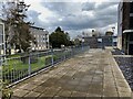
Newsom Place, St Albans
The way to the underground parking, between Blackfriars Court and Whitley Court. Old maps show that by the turn of the 19th and 20th centuries this area (bounded by Lemsford Road, Manor Road, St Peter's Road and Hatfield Road) was filling up with large detached houses with large gardens. Ian Capper refers to it in 2021 as the Oaklands College site Image : Newsom Place. His photo illustrates partial redevelopment that was completed in 2011. Construction works observed in 2023 suggest that even that is being replaced by blocks in the style shown above. Aerial photos show about 20 such blocks across the whole site.
Image: © Robin Stott
Taken: 6 Apr 2023
0.02 miles
6
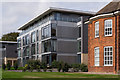
Newsom Place
A development of studios and apartments on the Oaklands College site off Lemsford Road, completed in 2011. Whilst some of the buildings are new-build, some were conversions of the original 1950s college buildings, as here, and these are grade II listed - see www.historicengland.org.uk/listing/the-list/list-entry/1392956. In the centre is Medd Court, with the new-build Trinity Court beyond.
Image: © Ian Capper
Taken: 5 Jul 2021
0.03 miles
7
Newsom Place, St Albans
The entry from Manor Road. Old maps show that by the turn of the 19th and 20th centuries this area (bounded by Lemsford Road, Manor Road, St Peter's Road and Hatfield Road) was filling up with large detached houses with large gardens. Ian Capper refers to it in 2021 as the Oaklands College site Image : Newsom Place. His photo illustrates partial redevelopment that was completed in 2011. Construction works observed in 2023 suggest that even that is being replaced by blocks in the style shown above. Aerial photos show about 20 such blocks across the whole site.
Image: © Robin Stott
Taken: 6 Apr 2023
0.03 miles
8
Oriel Court, Newsom Place
A block in a development of studios and apartments on part of the Oaklands College site off Manor Road, completed in 2011. To its right is part of Tunbridge Court, a redevelopment of one of the original buildings on the site (see Image).
Image: © Ian Capper
Taken: 4 Oct 2011
0.03 miles
9
Newsom Place
A development of studios and apartments on the Oaklands College site off Lemsford Road, completed in 2011. Whilst some of the buildings are new-build, some were conversions of the original 1950s college buildings, as here, and these are grade II listed - see www.historicengland.org.uk/listing/the-list/list-entry/1392956. In the centre is Medd Court, with Platt Court on the far left and Martin Court on the far right.
Image: © Ian Capper
Taken: 5 Jul 2021
0.03 miles
10
Tunbridge Court, Newsom Place
Redevelopment of one of the existing buildings on the Oaklands College site, in contrast to the modern new build of studios and apartments elsewhere on the site (see Image for example).
Image: © Ian Capper
Taken: 4 Oct 2011
0.04 miles