IMAGES TAKEN NEAR TO
St. Peters Close, ST. ALBANS, AL1 3ES
Introduction
This page details the photographs taken nearby to St. Peters Close, AL1 3ES by members of the Geograph project.
The Geograph project started in 2005 with the aim of publishing, organising and preserving representative images for every square kilometre of Great Britain, Ireland and the Isle of Man.

There are currently over 7.5m images from over14,400 individuals and you can help contribute to the project by visiting https://www.geograph.org.uk
Image Map
Images are licensed for reuse under creativecommons.org/licenses/by-sa/2.0
Notes
- Clicking on the map will re-center to the selected point.
- The higher the marker number, the further away the image location is from the centre of the postcode.
Image Listing (264 Images Found)
Images are licensed for reuse under creativecommons.org/licenses/by-sa/2.0
Image
Details
Distance
1
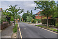
St Peter's Close
1930s cul-de-sac off St Peter's Street.
Image: © Ian Capper
Taken: 19 Aug 2021
0.01 miles
2
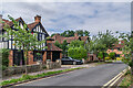
St Peter's Close
1930s cul-de-sac off St Peter's Street.
Image: © Ian Capper
Taken: 19 Aug 2021
0.01 miles
3
Pemberton Almshouses
Built in 1627 by Robert Pemberton, Listed Grade II. The wall and gateway are separately Listed Grade II. See also http://www.geograph.org.uk/photo/2614681 , http://www.geograph.org.uk/photo/2614707
Image: © Alan Murray-Rust
Taken: 2 Nov 2015
0.03 miles
4
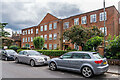
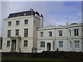
Grange Court
1930s block of 9 apartments on Grange Street.
Image: © Ian Capper
Taken: 5 Jul 2021
0.03 miles
5
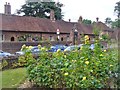
St Albans - Pemberton Almshouses
The almshouses on St Peter's Street were founded in 1627 by Roger Pemberton, High Sheriff of Hertfordshire.
Image: © Colin Smith
Taken: 13 Aug 2016
0.03 miles
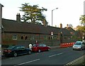
6
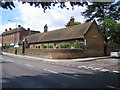
St Albans: Pemberton Almshouses
These almshouses were founded in 1627 by Roger Pemberton, High Sheriff of Hertfordshire, reputedly as atonement for an accident when he killed a poor widow with a bow and arrow. The inscription in the white tablet at the top of the entrance arch reads:
"With Five Pounds Pr. Annum Each
Out of the Mannor of Shelton in Bedfordshire
By ROGER PEMBERTON of St. Albans Esqr.
Who was bury'd in the Church of St. Peter
Novr. 20th. 1627"
The road in the foreground is the A1081 St Peters Street, and the road to the right is Grange Street.
Image: © Nigel Cox
Taken: 17 May 2007
0.04 miles
8
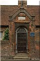
Gateway, The Pemberton Almshouses
Gateway to The Pemberton Almshouses (see Image). Note the iron shaft at the top of the gateway representing an arrow, commemorating the tradition that the founder of the almshouses, Roger Pemberton, had shot a widow by accident, in atonement for which he had founded the almshouses.
The gateway is grade II listed - for listing particulars see www.historicengland.org.uk/listing/the-list/list-entry/1103050.
For close up of the plaque above the gate, see Image
Image: © Ian Capper
Taken: 22 Sep 2011
0.04 miles
9
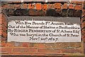
Plaque on gateway, The Pemberton Almshouses
Plaque on the gateway of The Pemberton Almshouses (see Image).
It reads "These six Alms Houses were Erected & Endowed With Five Pounds Pr. Annum Each Out of the Mannor of Shelton in Bedfordshire By ROGER PEMBERTON of St. Albans Esqr. Who was bury'd in the Church of St. Peter Novr. 20th. 1627."
Image: © Ian Capper
Taken: 16 Sep 2011
0.04 miles
10
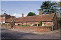
The Pemberton Almshouses
Built in 1627 in accordance with the will of Roger Pemberton, one time High Sheriff of Hertfordshire, following his death. He had ordered six almshouses to be built for poor widows, and had set up an endowment to provide the occupants with an allowance for food and clothing. He gave strict instructions on their behaviour, with the provision that they would lose their allowance as a first sanction, and their home if they failed to mend their ways.
Tradition has it that Pemberton had shot a widow by accident, and it was in atonement for this that he had founded the almshouses. Although there would seem to be no historical basis for this story, there is an iron spike representing an arrow above the gateway - see Image
Both the houses and the wall and gateway in front of it are grade II listed - for listing particulars see www.historicengland.org.uk/listing/the-list/list-entry/1347160 and www.historicengland.org.uk/listing/the-list/list-entry/1103050.
Image: © Ian Capper
Taken: 16 Sep 2011
0.04 miles