IMAGES TAKEN NEAR TO
St. Peters Street, ST. ALBANS, AL1 3EG
Introduction
This page details the photographs taken nearby to St. Peters Street, AL1 3EG by members of the Geograph project.
The Geograph project started in 2005 with the aim of publishing, organising and preserving representative images for every square kilometre of Great Britain, Ireland and the Isle of Man.

There are currently over 7.5m images from over14,400 individuals and you can help contribute to the project by visiting https://www.geograph.org.uk
Image Map
Images are licensed for reuse under creativecommons.org/licenses/by-sa/2.0
Notes
- Clicking on the map will re-center to the selected point.
- The higher the marker number, the further away the image location is from the centre of the postcode.
Image Listing (355 Images Found)
Images are licensed for reuse under creativecommons.org/licenses/by-sa/2.0
Image
Details
Distance
1
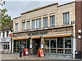
The Beech House
Pub/restaurant at 81 St Peter's Street, a 1930s art deco building, with the current occupiers having been here since 2014. Prior to this, the premises housed an Indian restaurant.
Image: © Ian Capper
Taken: 4 Nov 2021
0.01 miles
2
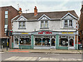
1 - 3 Catherine Street
Fish restaurant on Catherine Street. Until the 1980s the central portion was a wet fishmonger with an open frontage, since sympathetically renovated to fit in with the 1930s frontage of the remainder of the building.
Image: © Ian Capper
Taken: 4 Nov 2021
0.01 miles
3
Catherine Street at the junction of High Street, St Albans
Image: © David Howard
Taken: 22 Aug 2021
0.01 miles
5
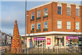
City Point
Retail/residential block on the corner of St Peter's Street and Catherine Street. On the left is a Christmas tree made up of gold and red glass baubles, as part of the city's Christmas decorations.
Image: © Ian Capper
Taken: 4 Jan 2020
0.02 miles
6
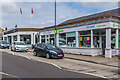
Catherine Street
1930s car showroom and 1990s shops on Catherine Street.
Image: © Ian Capper
Taken: 19 Aug 2021
0.02 miles
7
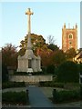
St Peter's (Church) Green
A small garden created around the war memorial. This dates to 1920-21, and was designed by Sir Edgar Wigram. Listed Grade II.
Image: © Alan Murray-Rust
Taken: 2 Nov 2015
0.03 miles
8
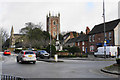
St Peter's Street
The northern end of the city centre, with St Peter's Church dominating. The war memorial is in front.
Image: © Bill Boaden
Taken: 27 Feb 2020
0.03 miles
9
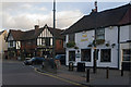
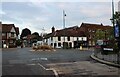
The Cock
A pub with 16th/early 17th century origins at the junction of Hatfield Road (formerly called Cock Lane) and St Peters Street. Grade II listed - for listing particulars see www.historicengland.org.uk/listing/the-list/list-entry/1251280.
Beyond, on the other side of Hatfield Road, is the Blacksmiths Arms - Image
Image: © Ian Capper
Taken: 3 Dec 2011
0.03 miles
10
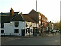
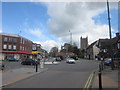
The Cock and St Peter's Street, east side
St Peter's Street has significant groupings of listed buildings, particularly towards the northern end.
In the foreground is The Cock public house. The modernised finish conceals a timber framed building dating from around 1700, the ground floor having been filled out below the jettied first floor. Listed Grade II.
Beyond is a series of Georgian frontages, some of which conceal earlier buildings, all Listed Grade II.
Image: © Alan Murray-Rust
Taken: 2 Nov 2015
0.03 miles