IMAGES TAKEN NEAR TO
Nuns Lane, ST. ALBANS, AL1 2HS
Introduction
This page details the photographs taken nearby to Nuns Lane, AL1 2HS by members of the Geograph project.
The Geograph project started in 2005 with the aim of publishing, organising and preserving representative images for every square kilometre of Great Britain, Ireland and the Isle of Man.

There are currently over 7.5m images from over14,400 individuals and you can help contribute to the project by visiting https://www.geograph.org.uk
Image Map
Images are licensed for reuse under creativecommons.org/licenses/by-sa/2.0
Notes
- Clicking on the map will re-center to the selected point.
- The higher the marker number, the further away the image location is from the centre of the postcode.
Image Listing (45 Images Found)
Images are licensed for reuse under creativecommons.org/licenses/by-sa/2.0
Image
Details
Distance
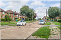
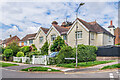
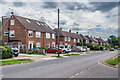
2
Butterfield Lane
Cul de sac off Cottonmill Lane, overlooking the River Ver watermeadows. Most of the houses date from the c.1950s.
Image: © Ian Capper
Taken: 5 Aug 2021
0.06 miles
4
Butterfield Lane
Cul de sac off Cottonmill Lane, overlooking the River Ver watermeadows.
Image: © Ian Capper
Taken: 20 Apr 2013
0.07 miles
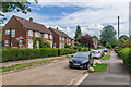
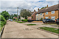
5
Butterfield Lane
Cul de sac off Cottonmill Lane, overlooking the River Ver watermeadows. Most of the houses date from the c.1950s, but the building here, on the junction of the road with Cottonmill Lane, first appearing on the 1924 25 inch map.
Image: © Ian Capper
Taken: 5 Aug 2021
0.08 miles
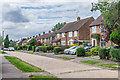
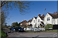
7
Butterfield Lane
Cul de sac off Cottonmill Lane, overlooking the River Ver watermeadows. Most of the houses date from the c.1950s.
Image: © Ian Capper
Taken: 5 Aug 2021
0.08 miles
8
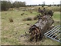
Ver Meadows
A decaying tree trunk and broken gate adorn the foreground of this view of Ver Meadows, an important example of chalkland watermeadow.
Image: © Martin Addison
Taken: 9 Mar 2006
0.08 miles
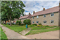
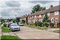
9
Cottonmill Lane
c.1950s housing in Cottonmill Lane. Although not developed until then, the route itself is much older, being the route from St Albans out to Sopwell from St Albans.
Image: © Ian Capper
Taken: 5 Aug 2021
0.09 miles