IMAGES TAKEN NEAR TO
New House Park, ST. ALBANS, AL1 1UH
Introduction
This page details the photographs taken nearby to New House Park, AL1 1UH by members of the Geograph project.
The Geograph project started in 2005 with the aim of publishing, organising and preserving representative images for every square kilometre of Great Britain, Ireland and the Isle of Man.

There are currently over 7.5m images from over14,400 individuals and you can help contribute to the project by visiting https://www.geograph.org.uk
Image Map
Images are licensed for reuse under creativecommons.org/licenses/by-sa/2.0
Notes
- Clicking on the map will re-center to the selected point.
- The higher the marker number, the further away the image location is from the centre of the postcode.
Image Listing (18 Images Found)
Images are licensed for reuse under creativecommons.org/licenses/by-sa/2.0
Image
Details
Distance
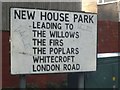
1
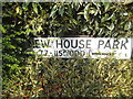
Overgrown sign for New House Park, Sopwell
Image: © David Howard
Taken: 28 May 2015
0.01 miles

7
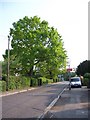
Two Urban Oaks - Mile House Lane
These trees are on the NW side of the lane and presumably were by the side of a field years ago before the current 1930s houses were built.
Image: © anthony helm
Taken: 28 Apr 2007
0.08 miles
8
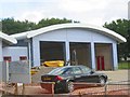
The new fire station in London Road
When operational the station will allow for quicker access to the motorways than is the case currently where vehicles must pass through the centre of the town.
Image: © Jack Hill
Taken: 15 Aug 2005
0.09 miles
9
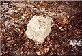
Old Milestone by the A1081, London Road, St Albans
St Albans plate by the A1081 (formerly A6), in parish of St Albans (St Albans District), approximately 500 metres South East of the Mile House Inn PH, by the West side of the road.
Milestone lost since 1970, and the Mile House Inn has since been demolished. The site of the old milestone is now close to a new roundabout for Highfield Park Drive.
Milestone Society National ID: HE_LH20
Image: © Milestone Society
Taken: Unknown
0.12 miles
10
Meadowcroft, Sopwell
Typical 1960s small housing estate
Image: © David Howard
Taken: 28 May 2015
0.16 miles