IMAGES TAKEN NEAR TO
De Tany Court, ST. ALBANS, AL1 1TX
Introduction
This page details the photographs taken nearby to De Tany Court, AL1 1TX by members of the Geograph project.
The Geograph project started in 2005 with the aim of publishing, organising and preserving representative images for every square kilometre of Great Britain, Ireland and the Isle of Man.

There are currently over 7.5m images from over14,400 individuals and you can help contribute to the project by visiting https://www.geograph.org.uk
Image Map
Images are licensed for reuse under creativecommons.org/licenses/by-sa/2.0
Notes
- Clicking on the map will re-center to the selected point.
- The higher the marker number, the further away the image location is from the centre of the postcode.
Image Listing (441 Images Found)
Images are licensed for reuse under creativecommons.org/licenses/by-sa/2.0
Image
Details
Distance
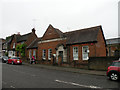
1
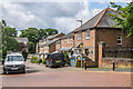
De Tany Court
1980s development off Belmont Hill, built on the site of former playing fields of St Albans School, and previously the formal gardens of Holywell House, home of Sarah Churchill, the Duchess of Marlborough, which had been demolished in 1837 when the present route of Holywell Hill was created.
Image: © Ian Capper
Taken: 24 Jul 2020
0.03 miles
2
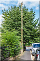
Sewer vent column
A sewer vent column (or "stinkpipe") in Belmont Hill.
Image: © Ian Capper
Taken: 24 Jul 2020
0.04 miles
3
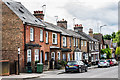
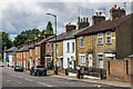
61 - 77 Holywell Hill
Mid 19th Century terraced houses built following the demolition of Holywell House, home of Sarah Churchill, the Duchess of Marlborough, which had been demolished in 1837 when the present route of Holywell Hill was created, replacing the previous route along Grove Road. Although not now formally used, this stretch of Holywell Hill is shown on older maps as Spencer Place, presumably in commemoration of the Spencer family of which the Duchess was part.
Image: © Ian Capper
Taken: 24 Jul 2020
0.05 miles
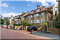
4
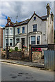
1 - 2 Belmont Hill
Late 19th Century house in Belmont Hill.
Image: © Ian Capper
Taken: 24 Jul 2020
0.05 miles
5
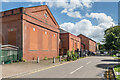
Holywell Pumping Station
Water pumping buildings in Holywell Hill. The nearest building, formerly the water company offices, dates from 1911 and now houses a nursery school. the other buildings, which are Edwardian, are still in use as a pumping station.
Image: © Ian Capper
Taken: 21 Aug 2020
0.05 miles
6
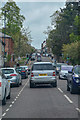
St Albans : Holywell Hill A5183
Looking along Holywell Hill.
Image: © Lewis Clarke
Taken: 27 Apr 2019
0.05 miles
7
Former waterworks building
Former waterworks building dating from 1911, situated close to where Holywell Hill crosses the River Ver. It now houses a nursery school. Locally listed.
Image: © Ian Capper
Taken: 4 Dec 2011
0.06 miles
8
78 - 108 Holywell Hill
Mid 19th Century terraced houses built following the demolition of Holywell House, home of Sarah Churchill, the Duchess of Marlborough, which had been demolished in 1837 when the present route of Holywell Hill was created replacing the previous route behind the houses, along Grove Road. Although not now formally used, this stretch of Holywell Hill is shown on older maps as Spencer Place, presumably in commemoration of the Spencer family of which the Duchess was part. The name is still show on the wall of the house on the far right of the photo.
Image: © Ian Capper
Taken: 24 Jul 2020
0.06 miles
9
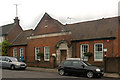
Former Water Company, Holywell Hill
Built 1908. Now Abbey View Nursery & Pre-school.
Image: © Keith Edkins
Taken: 1 Jun 2016
0.06 miles
10
Belmont Hill
Early 20th Century houses in Belmont Hill.
Image: © Ian Capper
Taken: 24 Jul 2020
0.06 miles