IMAGES TAKEN NEAR TO
Cornwall Road, ST. ALBANS, AL1 1SH
Introduction
This page details the photographs taken nearby to Cornwall Road, AL1 1SH by members of the Geograph project.
The Geograph project started in 2005 with the aim of publishing, organising and preserving representative images for every square kilometre of Great Britain, Ireland and the Isle of Man.

There are currently over 7.5m images from over14,400 individuals and you can help contribute to the project by visiting https://www.geograph.org.uk
Image Map
Images are licensed for reuse under creativecommons.org/licenses/by-sa/2.0
Notes
- Clicking on the map will re-center to the selected point.
- The higher the marker number, the further away the image location is from the centre of the postcode.
Image Listing (98 Images Found)
Images are licensed for reuse under creativecommons.org/licenses/by-sa/2.0
Image
Details
Distance
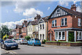
1
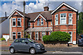
20 & 22 Cornwall Road
A pair of semi-detached Edwardian villas in Cornwall Road. Note the ornate terracotta divider between the central first floor windows.
Image: © Ian Capper
Taken: 5 Jul 2021
0.00 miles
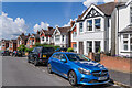
2
24 - 30 Cornwall Road
Early 20th Century housing in Cornwall Road.
Image: © Ian Capper
Taken: 5 Jul 2021
0.01 miles
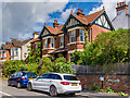
3
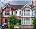
12 & 14 Cornwall Road
A pair of semi-detached Edwardian villas in Cornwall Road. Note the ornate arches above the first floor windows.
Image: © Ian Capper
Taken: 5 Jul 2021
0.02 miles
4
Cornwall Road
Early 20th Century housing in Cornwall Road.
Image: © Ian Capper
Taken: 5 Jul 2021
0.02 miles
5
Cornwall Road
Mainly semi-detached Edwardian villas in Cornwall Road.
Image: © Ian Capper
Taken: 5 Jul 2021
0.02 miles
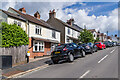
6
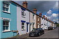
Riverside Road
Turn of the 19th/20th Century terraced housing on a road built on the line of a former footpath. Originally a cul-de-sac called Longmire Road, the current name first appeared on the 1972 1:1,250 map, when the road was extended westwards to meet Cottonmill Lane. These houses back onto former watercress beds alongside the River Ver. Note the ornate stone headers to the windows, unique on St Albans.
Image: © Ian Capper
Taken: 5 Jul 2021
0.04 miles
7
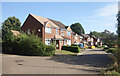
Orient Close, St Albans
Housing beside the Alban Way, a cycle path along an old railway line between Hatfield and St Albans.
Image: © Des Blenkinsopp
Taken: 25 Aug 2024
0.06 miles
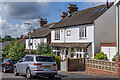
8
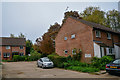
St Albans : Riverside Court
Looking along Riverside Court.
Image: © Lewis Clarke
Taken: 4 Oct 2018
0.07 miles
9
Ramsbury Road
Edwardian villas in Ramsbury Road.
Image: © Ian Capper
Taken: 5 Jul 2021
0.07 miles
10
16a Ramsbury Road
Large Edwardian villa at the junction of Ramsbury Road and Approach Road.
Image: © Ian Capper
Taken: 5 Jul 2021
0.07 miles